Seifhennersdorf
| Seifhennersdorf | ||
|---|---|---|
.jpg) | ||
| ||
 Seifhennersdorf | ||
Location of Seifhennersdorf within Görlitz district 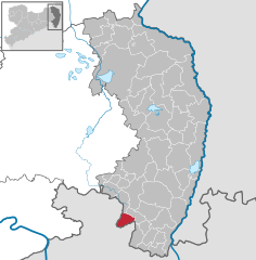
 | ||
| Coordinates: 50°56′N 14°37′E / 50.933°N 14.617°ECoordinates: 50°56′N 14°37′E / 50.933°N 14.617°E | ||
| Country | Germany | |
| State | Saxony | |
| District | Görlitz | |
| Government | ||
| • Mayor | Karin Berndt (UBS) | |
| Area | ||
| • Total | 19.13 km2 (7.39 sq mi) | |
| Population (2013-12-31)[1] | ||
| • Total | 3,883 | |
| • Density | 200/km2 (530/sq mi) | |
| Time zone | CET/CEST (UTC+1/+2) | |
| Postal codes | 02782 | |
| Dialling codes | 03586 | |
| Vehicle registration | GR | |
| Website | www.seifhennersdorf.de | |

Seifhennersdorf is a town in the district Görlitz, in the Free State of Saxony, Germany. It is situated on the border with the Czech Republic, and the Czech towns of Rumburk and Varnsdorf lie across the border to the north-east and south of town.
Seifhennersdorf is 8 km south of Ebersbach and 14 km west of Zittau.
History
During World War II, a subcamp of Flossenbürg concentration camp was located in the town.[2]
References
- ↑ "Statistisches Landesamt des Freistaates Sachsen – Bevölkerung des Freistaates Sachsen jeweils am Monatsende ausgewählter Berichtsmonate nach Gemeinden" (PDF). Statistisches Landesamt des Freistaates Sachsen (in German). 6 September 2014.
- ↑ Christine O'Keefe. Concentration Camps