Sebergham
Sebergham is a small village and civil parish in the English county of Cumbria. It is located on the B5305, south of Carlisle and south-east of Wigton.
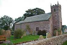
St. Mary's church is medieval in origin, repaired in the 18th century and with a tower added in the 1820s. It is a Grade II* listed building and lies on the Cumbria Way walk. [1] Sebergham Bridge dates from 1689 and Bell Bridge from 1772: both are Grade II listed.[2][3]
Sebergham Castle is a farmhouse, formerly known as Colerigg Hall, transformed into a Gothick folly in the late eighteenth century.[4] A mile to the south-west of the village is Warnell Hall, a fortified house which is now a farmhouse. It was built in the 16th century incorporating part of a 14th-century pele tower.[5]
References
External links
- Map sources for Sebergham
Coordinates: 54°45′59″N 2°59′22″W / 54.766261°N 2.989483°W