Scotia Plate

The Scotia Plate (Spanish: Placa Scotia), named after the Scotia Sea, which overlies it, is a tectonic plate on the edge of the South Atlantic and Southern Ocean. Thought to have formed during the early Eocene with the opening of the Drake Passage that separates South America from Antarctica, it is a minor plate whose movement is largely controlled by the two major plates that surround it; the South American plate and Antarctic plate. Having formed as oceanic crust, it is almost completely submerged with only the small exceptions of the South Georgia Islands on its north-eastern edge and the southern tip of South America.[1]
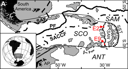
Tectonic setting
Bounded by subducting, spreading and transform ridges, the Scotia plate lies in a unique setting. Surrounded by two major plates and three minor ones, its tectonic location is generally reflective of the relative motion between the Antarctic plate and the South American plate.[1]
The southern edge of the plate is bordered by the Antarctic plate forming the South Scotia Ridge, a left-lateral transform boundary sliding at a rate of roughly 11 mm/yr that occupies the southern half of the Antarctic-Scotia plate boundary.[1] The relative motion between the Scotia plate and the Antarctic plate on the western boundary is roughly 13 mm/yr. Though the South Scotia Ridge is overall a transform fault, small sections of the ridge are spreading to make up for the somewhat jagged shape of the boundary.[1] The relative motion between the Scotia plate and the Antarctic plate on the western boundary is roughly 13 mm/yr.
The western edge of the plate is bounded by the Antarctic plate, forming the Shackleton Fracture Zone and the Southern Chile Trench. The Southern Chile Trench is a southern extension of the subduction of the Antarctic and Nazca plates below South America. Heading south along the ridge, the subduction rate decreases until its remaining oblique motion evolves into the Shackleton Fracture Zone transform boundary.
The northern edge of the Scotia plate is bounded by the South American plate, forming the North Scotia ridge. The North Scotia ridge is a left lateral transform boundary with a transform rate of roughly 7.1 mm/yr.[1]
The eastern edge of the Scotia plate is a spreading ridge bounded by the South Sandwich microplate forming the East Scotia Ridge.[1] The East Scotia Ridge is a back-arc spreading ridge that formed due to subduction of the South American plate below the South Sandwich plate along the South Sandwich Island arc. Exact spreading rates are still being disputed in the literature, but it has been agreed that rates range between 60–90 mm/yr.[2]
The south-western edge of the plate is bounded by the Shetland microplate separating the Shackleton Fracture Zone and the South Scotia Ridge.[1]
South Georgia Islands
Experts in plate tectonics have been unable to determine whether the South Georgian Islands are part of the Scotia plate or have been recently accreted to the South American plate. Surface expressions of the plate boundary are found north of the islands suggesting a long-term presence of the transform fault there. Yet seismic studies have identified strain and thrusting south of the islands indicating the possible shift of the transform fault to an area south of the island. It has also been suggested that the plate bearing the islands may have broken off from the Scotia plate, forming a new independent South Georgia microplate, yet there is little evidence to make this conclusion.[1]
Paleo-tectonics
The timing of the formation of the Scotia plate and opening of the Drake Passage have long been the subject of much debate due to the important implications for changes in ocean currents and shifts in paleoclimate. The thermal isolation of Antarctica , engendering the formation of the Antarctic ice sheet, has largely been attributed to the opening of the Drake Passage.[3][4]
During the early Eocene (50 Ma), the Drake Passage between the southern tip of South America at Cape Horn and the South Shetland Islands of Antarctica was a small opening with limited circulation. A change in relative motion between the South American plate and the Antarctic plate would have severe effects, causing seafloor spreading and the formation of the Scotia plate.[3] Marine geophysical data indicates that motion between the South American plate and the Antarctic plate shifted from N-S to WNW-ESE accompanied by an eightfold increase in the separation rate.[4] This shift in spreading initiated crustal thinning and by 30-34 Ma, the Mid-Scotia spreading ridge formed. Spreading began to generate two new oceanic plates between South American and Antarctica, the so-called Magellan and Central Scotia plates. Thinner and denser than the continental Antarctic and South American plates, the growing Magellan and Central Scotia plates formed a deep and increasingly wide passage, the Drake Passage between South America and Antarctica. The eventual death of the Mid-Scotia ridge led the Magellan and Central Scotia plates to join, forming the Scotia plate as seen today.
See also
References
- ↑ 1.0 1.1 1.2 1.3 1.4 1.5 1.6 1.7 Thomas, C.; Livermore, R.; Pollitz, F. (2003). "Motion of the Scotia Sea Plate". Geophysical Journal International 155: 789–804. Bibcode:2003GeoJI.155..789T. doi:10.1111/j.1365-246X.2003.02069.x.
- ↑ 10.1144/GSL.SP.2003.219.01.15 Geological Society, London, Special Publications 2003, v. 219, p. 315-331
- ↑ 3.0 3.1 Pelayo, A.M.; Wiens,D.A (1989). "Seismotectonics and relative plate motion in the Scotia sea region". Journal of Geophysical Research 94 (86): 7293–7320. Bibcode:1989JGR....94.7293P. doi:10.1029/JB094iB06p07293.
- ↑ 4.0 4.1 Livermore, R; Nankiwell, A.; Eagles, G.; Morris, P. (2005). "Paleogene opening of the Drake Passage". Earth and Planetary Science Letters 236 (1-2): 459–470. doi:10.1016/j.epsl.2005.03.027.
| |||||||||||||||||||||||||

| ||||||||||||||||||||