Schwarzenbach am Wald
| Schwarzenbach a.Wald | ||
|---|---|---|
| ||
 Schwarzenbach a.Wald | ||
Location of Schwarzenbach a.Wald within Hof district 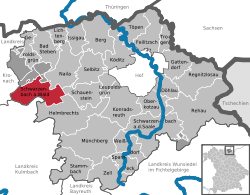 | ||
| Coordinates: 50°17′0″N 11°37′15″E / 50.28333°N 11.62083°ECoordinates: 50°17′0″N 11°37′15″E / 50.28333°N 11.62083°E | ||
| Country | Germany | |
| State | Bavaria | |
| Admin. region | Oberfranken | |
| District | Hof | |
| Government | ||
| • Mayor | Dieter Frank (CSU) | |
| Area | ||
| • Total | 36.50 km2 (14.09 sq mi) | |
| Population (2013-12-31)[1] | ||
| • Total | 4,598 | |
| • Density | 130/km2 (330/sq mi) | |
| Time zone | CET/CEST (UTC+1/+2) | |
| Postal codes | 95131 | |
| Dialling codes | 09289 | |
| Vehicle registration | HO | |
| Website | www.schwarzenbach-wald.de | |

Schwarzenbach am Wald is a town in the district of Hof, in Bavaria, Germany. It is situated 21 km west of Hof, and 23 km northeast of Kulmbach.
Geographic
Geographical Situation
Schwarzenbach am Wald is situated in a natural environment at the bottom of the Döbraberg in the natural park Frankenwald
City Structure
|
|
|
References
- ↑ "Fortschreibung des Bevölkerungsstandes". Bayerisches Landesamt für Statistik und Datenverarbeitung (in German). 31 December 2013.