Saville Dam
| Saville Dam | |
|---|---|
 Barkhamsted Reservoir, Saville Dam | |
 | |
| Location | Barkhamsted, Connecticut |
| Coordinates | 41°54′36″N 72°57′17″W / 41.91000°N 72.95472°WCoordinates: 41°54′36″N 72°57′17″W / 41.91000°N 72.95472°W |
| Opening date | 1948 |
| Operator(s) | Metropolitan District Commission |
| Dam and spillways | |
| Impounds | Farmington River (Eastern branch) |
| Height | 135 feet (41 m) |
| Length | 1,950 feet (590 m) |
| Reservoir | |
| Creates | Barkhamsted Reservoir |
| Total capacity | 36.8 billion US gallons (139,000,000 m3) |
| Catchment area | 53.8 square miles (139 km2) |
| Surface area | 4.2 square miles (11 km2) |
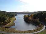
Saville Dam is an earthen embankment dam with masonry work on the eastern branch of the Farmington River 4 kilometres (2.5 mi) southwest of Barkhamsted, Connecticut. The dam is 135 ft. (41 m) tall and 1,950 ft. (590 m) long and has an uncontrolled spillway on its western portion. It creates the Barkhamsted Reservoir which has a volume of 36.8 billion US gallons (139,000,000 m3) and is the primary water source for Hartford, Connecticut.

In 1927, the Metropolitan District Commission (MDC) began to buy up land where the present day dam and reservoir are. By 1936, the MDC began to strip the land of lumber and buildings and started construction on the dam as well. Construction on the dam was completed in 1940 and the Barkhamsted Reservoir was full by 1948. The dam was named after its chief engineer, Caleb Mills Saville. The Barkhamsted Reservoir is nearly 8 miles (13 km) long and extends north near Hartland, Connecticut, nearly to Massachusetts.[1][2]
The reservoir flooded many buildings and farms of Barkhamsted, including the village of Barkhamsted Hollow.[3]