Sauvie Island
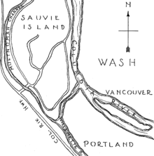
Sauvie Island, in the U.S. state of Oregon, originally Wapato Island or Wappatoo Island, is the largest island along the Columbia River, at 26,000 acres (105 km²), and one of the largest river islands in the United States. It lies approximately ten miles northwest of downtown Portland, between the Columbia River to the east, the Multnomah Channel to the west, and the Willamette River to the south. Sturgeon Lake, in the north central part of the island, is the most prominent water feature. The land area is 84.82 km² (32.75 sq mi, or 20,959 acres), which is larger than Manhattan. Most of the island is in Multnomah County, but the northern third is in Columbia County. The Sauvie Island Bridge provides access across the Multnomah Channel from U.S. Route 30 and was completed in June 2009, replacing the first bridge to connect the island to the mainland which was opened on 30 December 1950.
The island is predominantly farmland and wildlife refuge and is a popular place for picking pumpkins, hunting geese and kayaking. There were 1,078 year-round residents at the 2000 census. There is an industrial zone and small grocery store in the southeast corner, near the bridge. Bicyclists flock to the island because its flat topography and lengthy low-volume roads make it ideal for cycling. Its nearest incorporated neighbors are the Portland-Vancouver metropolitan area to its south and southeast; St. Helens across the Multnomah Channel from the extreme northern tip of the island; and Scappoose, across the Multnomah Channel to the west.
History
- 1792 – British Lieutenant William Broughton in George Vancouver's expedition explores the island and names the northern tip "Warrior Point" after being greeted offshore by 23 canoes of armed Multnomah Indians.[1]
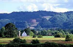
- October 29 – Mount Hood was named on October 29, 1792, as Lt. Broughton observed its peak from Belle Vue Point at the southern tip of Sauvie Island during his travels up the Columbia River, writing A very high, snowy mountain now appeared rising beautifully conspicuous in the midst of an extensive tract of low or moderately elevated land (location of today's Vancouver, Washington) lying S 67 E., and seemed to announce a termination to the river. Lt. Broughton named the mountain after British admiral Samuel Hood.
- November 4, 1805 – The Lewis and Clark expedition lands, names it "Wapato Island" after the abundance of Broadleaf arrowhead plants, which are also known as "Indian potato" and were a major foodstuff for indigenous peoples in the Pacific Northwest.[2]
- During the next decades the natives weather outbreaks of smallpox, syphilis, measles and tuberculosis.
- 1829 - A horrifying epidemic of a fever known as "the ague" sweeps across the land.[3]
- 1832 - So much of the native population has died in the epidemic, they are nearly extinct;[3][4] Dr. McLoughlin of the Hudson's Bay Company removes survivors and burns settlements.[4]
- 1834 – American Nathaniel Jarvis Wyeth builds and occupies Fort William, a small trading post, to compete with the British; abandoned 1836.[2]
- c. 1836 – Hudson's Bay Company establishes dairies on the island, managed by French-Canadian employee Laurent Sauvé (after whom the island is now named).
- 1843 – The opening of the Oregon Trail makes it possible for American settlers to come to the island from the Midwest.[5]
- 1851 – Mouth of Willamette post office is established; renamed Souvies Island the following year.
- 1858 – James Bybee builds Bybee–Howell House. The structure was added to the NRHP in 1974, and is part of Howell Territorial Park.[6]
- 1889 – Warrior Rock Lighthouse established at Warrior Point.
- 1930s – The Army Corps of Engineers builds flood-control dikes.
- 1940s – Sauvie Island Wildlife Area acquired by the state of Oregon.[7]
- November 29, 1943 – Sauvie Island Conservation District is formed by unanimous vote.[8]
- December 30, 1950 – Sauvie Island Bridge opens; Sauvie Island Ferry, the last ferry in the Portland metropolitan area,[9] closes.
- 2006 – Multnomah County begins construction of new Sauvie Island Bridge.
- 2009 – New Sauvie Island Bridge opens with a parade and a performance by the Oregon Crusaders Drum and Bugle Corps.
Recreational beaches
Reeder Beach does not have public beach access. All public beaches on Sauvie Island are down the road from Reeder Beach approximately four miles. They are: Walton Beach, North Unit Beach, and the clothing-optional Collins Beach[10] on the island's east coast along NW Reeder Road's last few miles past the end of the pavement. The beaches are open from dawn to 10:00 p.m., and are closed to overnight use and camping. Open fires are not allowed. Dogs are allowed if they are leashed. This section of the beach is often a party like environment on warm and sunny days. [11] Beach parking is subject to Sauvie Island Wildlife Area parking permits.[12] They are available at all the stores on the island. Vehicles without a permit are subject to a ticket costing around $75.
Farms
Sauvie Island is home to dozens of private farms, from nurseries and gardens, to about a dozen fruit and vegetable farms open for public U-picking.[13] Crops include strawberries, raspberries, marionberries, blackberries, blueberries, peaches, pears, sweet corn, cherries, broccoli, lettuce, cauliflower, zucchini, tomatoes, green beans, cucumbers, pumpkins, herbs, and others.[14] Along with crops these farms also include activities such as hay rides, cow trains, and mazes.
References
- ↑ McArthur, Lewis A.; Lewis L. McArthur (1992) [1928]. Oregon Geographic Names (Sixth Edition ed.). Portland, Oregon: Oregon Historical Society Press. p. 886. ISBN 0-87595-277-1.
- ↑ 2.0 2.1 McArthur, Lewis A.; Lewis L. McArthur (1992) [1928]. Oregon Geographic Names (Sixth Edition ed.). Portland, Oregon: Oregon Historical Society Press. p. 743. ISBN 0-87595-277-1.
- ↑ 3.0 3.1 Sauvie Island: Historical Facts
- ↑ 4.0 4.1 Oregon: End of the Trail. North American Book Dist LLC. 1972 [1940]. p. 277. ISBN 0403021863.
- ↑ Oregon Bound: The Overland Journey of Alexander and Rebecca McQuinn, 1844. McQuinn Family Pioneer Cemetery Association. 1997. p. 100.
- ↑ Metro: Howell Territorial Park
- ↑ Sauvie Island Wildlife Area
- ↑ West Multnomah Soil and Water Conservation District
- ↑ Sneath, Sara (October 1, 2013). "Portland Bridge Quiz". Willamette Week. Retrieved 2014-12-27.
- ↑ Oregon Clothing-Optional Beach Alliance (ORCOBA) - Sauvie Island (Collins Beach)
- ↑
- ↑ Sauvie Island Parking Permit, Daily - Oregon Licenses, Permits and Registrations
- ↑ "Farm Stands & Family Fun". Retrieved October 25, 2013.
- ↑ http://www.sauvieislandfarms.com/crops_we_grow_1.htm
External links
- Multnomah County's Rural Area Plan for the island
- Sauvie Island Wildlife Area, from the website of the Oregon Department of Fish and Wildlife
- The Bybee House on Sauvie's Island, from the Historic American Buildings Survey at the Library of Congress
- Sauvie Island, Oregon section of Lyn Topinka's photo essay Lewis & Clark's Columbia River
- Collins Beach site about Sauvie Island's clothing optional beach from the Oregon Clothing-Optional Beach Alliance
| ||||||||||||||||||||||||
Coordinates: 45°42′59″N 122°48′04″W / 45.71639°N 122.80111°W