Satka
| Satka (English) Сатка (Russian) | |
|---|---|
| - Town[1] - | |
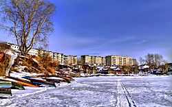 View of Satka | |
 Satka | |
|
| |
.png) |
|
|
| |
| Administrative status (as of June 2014) | |
| Country | Russia |
| Federal subject | Chelyabinsk Oblast[1] |
| Administrative district | Satkinsky District[1] |
| Town | Satka[1] |
| Administrative center of | Satkinsky District,[1] Town of Satka[1] |
| Municipal status (as of June 2014) | |
| Municipal district | Satkinsky Municipal District[1] |
| Urban settlement | Satkinskoye Urban Settlement[1] |
| Administrative center of | Satkinsky Municipal District,[1] Satkinskoye Urban Settlement[2] |
| Statistics | |
| Population (2010 Census) | 45,178 inhabitants[3] |
| Time zone | YEKT (UTC+05:00)[4] |
| Founded | November 19, 1758 |
| Postal code(s)[5] | 456910, 456912–4556915, 456918 |
|
| |
| Satka on WikiCommons | |
Satka (Russian: Са́тка) is a town and the administrative center of Satkinsky District in Chelyabinsk Oblast, Russia, located on the western slope of the Southern Ural Mountains on the bank of the Satka River, 190 kilometers (120 mi) from Chelyabinsk, the administrative center of the oblast. Population: 45,178 (2010 Census);[3] 49,686 (2002 Census);[6] 50,664 (1989 Census).[7]
History
It was founded on November 19, 1758 as an iron mining factory. Magnesite, a mineral essential to the manufacture of refractory brick used in blast furnaces, was discovered there.
Administrative and municipal status
Within the framework of administrative divisions, Satka serves as the administrative center of Satkinsky District.[1] As an administrative division, it is, together with ten rural localities, incorporated within Satkinsky District as the Town of Satka.[1] As a municipal division, the Town of Satka is incorporated within Satkinsky Municipal District as Satkinskoye Urban Settlement.[1]
Economy
The major industry in the town is the extraction of magnesite and other ores along with metallurgical plants to process the ore.
There is a small tourist industry because of the town's location in the center of the Ural Mountains near Zyuratkul National Park. There is also a nearby historic site at Porogi where the first hydro-electric generator in Russia was installed.
Transportation
Although there is a railway station in Satka, it is a spur line so connections are inconvenient.
Education
In addition to secondary schools, there is a satellite campus of the Chelyabinsk State University.
References
Notes
- ↑ 1.0 1.1 1.2 1.3 1.4 1.5 1.6 1.7 1.8 1.9 1.10 1.11 Resolution #161
- ↑ Федеральная служба государственной статистики. Федеральное агентство по технологическому регулированию и метрологии. №ОК 033-2013 1 января 2014 г. «Общероссийский классификатор территорий муниципальных образований. Код 75 649 101». (Federal State Statistics Service. Federal Agency on Technological Regulation and Metrology. #OK 033-2013 January 1, 2014 Russian Classification of Territories of Municipal Formations. Code 75 649 101. ).
- ↑ 3.0 3.1 Russian Federal State Statistics Service (2011). "Всероссийская перепись населения 2010 года. Том 1" [2010 All-Russian Population Census, vol. 1]. Всероссийская перепись населения 2010 года (2010 All-Russia Population Census) (in Russian). Federal State Statistics Service. Retrieved June 29, 2012.
- ↑ Правительство Российской Федерации. Федеральный закон №107-ФЗ от 3 июня 2011 г. «Об исчислении времени», в ред. Федерального закона №248-ФЗ от 21 июля 2014 г. «О внесении изменений в Федеральный закон "Об исчислении времени"». Вступил в силу по истечении шестидесяти дней после дня официального опубликования (6 августа 2011 г.). Опубликован: "Российская газета", №120, 6 июня 2011 г. (Government of the Russian Federation. Federal Law #107-FZ of June 31, 2011 On Calculating Time, as amended by the Federal Law #248-FZ of July 21, 2014 On Amending Federal Law "On Calculating Time". Effective as of after sixty days following the day of the official publication.).
- ↑ Почта России. Информационно-вычислительный центр ОАСУ РПО. (Russian Post). Поиск объектов почтовой связи (Postal Objects Search) (Russian)
- ↑ Russian Federal State Statistics Service (May 21, 2004). "Численность населения России, субъектов Российской Федерации в составе федеральных округов, районов, городских поселений, сельских населённых пунктов – районных центров и сельских населённых пунктов с населением 3 тысячи и более человек" [Population of Russia, Its Federal Districts, Federal Subjects, Districts, Urban Localities, Rural Localities—Administrative Centers, and Rural Localities with Population of Over 3,000] (XLS). Всероссийская перепись населения 2002 года [All-Russia Population Census of 2002] (in Russian). Retrieved August 9, 2014.
- ↑ Demoscope Weekly (1989). "Всесоюзная перепись населения 1989 г. Численность наличного населения союзных и автономных республик, автономных областей и округов, краёв, областей, районов, городских поселений и сёл-райцентров" [All Union Population Census of 1989: Present Population of Union and Autonomous Republics, Autonomous Oblasts and Okrugs, Krais, Oblasts, Districts, Urban Settlements, and Villages Serving as District Administrative Centers]. Всесоюзная перепись населения 1989 года[All-Union Population Census of 1989] (in Russian). Институт демографии Национального исследовательского университета: Высшая школа экономики [Institute of Demography at the National Research University: Higher School of Economics]. Retrieved August 9, 2014.
Sources
- Законодательное Собрание Челябинской области. Постановление №161 от 25 мая 2006 г. «Об утверждении перечня муниципальных образований (административно-территориальных единиц) Челябинской области и населённых пунктов, входящих в их состав», в ред. Постановления №2255 от 23 октября 2014 г. «О внесении изменений в перечень муниципальных образований (административно-территориальных единиц) Челябинской области и населённых пунктов, входящих в их состав». Вступил в силу со дня официального опубликования. Опубликован: "Южноуральская панорама", №111–112, 14 июня 2006 г. (Legislative Assembly of Chelyabinsk Oblast. Resolution #161 of November 25, 2006 On Adoption of the Registry of the Municipal Formations (Administrative-Territorial Units) of Chelyabinsk Oblast and of the Inhabited Localities They Comprise, as amended by the Resolution #2255 of October 23, 2014 On Amending the Registry of the Municipal Formations (Administrative-Territorial Units) of Chelyabinsk Oblast and of the Inhabited Localities They Comprise. Effective as of the official publication date.).
External links
- Official website of Satka (Russian)
- OAO Magnezit, the major employer in the town (Russian)
| |||||||||||||||||||||