Sassandra
| Sassandra | |
|---|---|
| Town and commune | |
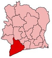
 Sassandra Location in Côte d'Ivoire | |
| Coordinates: 4°57′N 6°05′W / 4.950°N 6.083°WCoordinates: 4°57′N 6°05′W / 4.950°N 6.083°W | |
| Country |
|
| Region | Bas-Sassandra |
| Department | Sassandra Department |
| Time zone | GMT (UTC+0) |
Sassandra is the chief town in Sassandra Department of Côte d'Ivoire. The department is located in Bas-Sassandra Region. The town of Sassandra lies on the Gulf of Guinea at the mouth of the Sassandra River. The town was founded by the Portuguese as Santo André and was later run by the British, then the French as a seaport for timber. The town declined in the 1960s after San Pédro's port was completed. Its main industry is now fishing.
Sassandra is known for its beaches and lighthouse, while the Gaoulou National Park lies nearby. It is served by Sassandra Airport.
Climate
| Climate data for Sassandra (1961-1990) | |||||||||||||
|---|---|---|---|---|---|---|---|---|---|---|---|---|---|
| Month | Jan | Feb | Mar | Apr | May | Jun | Jul | Aug | Sep | Oct | Nov | Dec | Year |
| Average high °C (°F) | 30.1 (86.2) |
30.1 (86.2) |
31.0 (87.8) |
30.9 (87.6) |
29.8 (85.6) |
27.9 (82.2) |
27.1 (80.8) |
26.5 (79.7) |
27.5 (81.5) |
28.5 (83.3) |
29.6 (85.3) |
29.5 (85.1) |
29.0 (84.2) |
| Average low °C (°F) | 22.3 (72.1) |
23.0 (73.4) |
23.2 (73.8) |
23.4 (74.1) |
23.1 (73.6) |
22.0 (71.6) |
22.7 (72.9) |
22.0 (71.6) |
22.0 (71.6) |
22.4 (72.3) |
22.8 (73) |
22.6 (72.7) |
22.6 (72.7) |
| Average rainfall mm (inches) | 15.8 (0.622) |
35.7 (1.406) |
52.6 (2.071) |
96.9 (3.815) |
235.1 (9.256) |
529.1 (20.831) |
191.4 (7.535) |
32.1 (1.264) |
43.6 (1.717) |
84.5 (3.327) |
119.6 (4.709) |
72.8 (2.866) |
1,509.2 (59.417) |
| Mean monthly sunshine hours | 207.7 | 194.9 | 210.8 | 219.0 | 182.9 | 111.0 | 130.2 | 124.0 | 153.0 | 217.0 | 225.0 | 207.7 | 2,183.2 |
| Source: Hong Kong Observatory [1] | |||||||||||||
External links
- ↑ "Climatological Information for Sassandra, Cote d'Ivoire". The Government of the Hong Kong Special Administrative Region. Retrieved 2011-10-04.
| |||||||||||||||||||||||||||||