Sarkuwa
| Sarkuwa सर्कुवा | |
|---|---|
| Village development committee | |
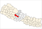
 Sarkuwa Location in Nepal | |
| Coordinates: 28°10′N 83°36′E / 28.17°N 83.60°ECoordinates: 28°10′N 83°36′E / 28.17°N 83.60°E | |
| Country |
|
| Zone | Dhaulagiri Zone |
| District | Baglung District |
| Population (1991) | |
| • Total | 2,516 |
| • Religions | Hindu |
| Time zone | Nepal Time (UTC+5:45) |
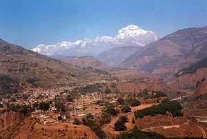
Sarkuwa is a village development committee of Baglung District of the Dhaulagiri Zone, situated in the western Nepal. At the time of the 1991 Nepal census it had a population of 2,516 and had 495 houses in the village.[1] Sarkuwa is situated in the Southern part of Baglung district. It is surrounded by Kusmishera, Damek, Paiyunthantap, Rangkhani, Jaidi, Arjewa and Binamare Village Development Committees. It has one of the oldest highschools of Baglung district and it has turned in to a Higher Secondary School (Janata Higher Secondary School situated at Ward No. 6- Sarkuwa) since 2006. Sarkuwa has five Elementary schools (in Maulachha, Sisnera, Tallamadi, Gairamadi and Ganwo). People from Brahmin, Chhetri, Thakuri, Magar, Sarki and Kami races are living in Sarkuwa. All of them follow Hindu religion. All of the population depends on agriculture. Rice, wheat, millet and corn are the major productions. Four villages of Sarkuwa (Maulachha, Sisnera, Ekrate-Ratamata and Sarkuwa) have been electrified from Theule Khola Hydro Project (25 KW), one (Tallamadi)from Tallamadi Microhydro and the rest from solar batteries. Part of Sarkuwa and Gairamadi are getting electricity from a hydroproject in the neighboring Damek VDC. Telecommunication is accessible in almost all villages now. Two branches of raw motorway have been extended from Kusmishera through Sarkuwa.[2]
References
- ↑ "Nepal Census 2001". Nepal's Village Development Committees. Digital Himalaya. Retrieved 2008-08-23.
- ↑ Template:Secretary, Sarkuwa VDC