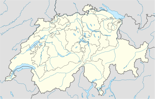
Sargans
| Sargans | ||
|---|---|---|
 | ||
| ||
 Sargans | ||
|
Location of Sargans 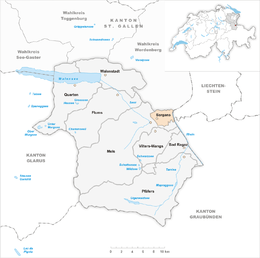 | ||
| Coordinates: 47°02′N 9°26′E / 47.033°N 9.433°ECoordinates: 47°02′N 9°26′E / 47.033°N 9.433°E | ||
| Country | Switzerland | |
| Canton | St. Gallen | |
| District | Wahlkreis Sarganserland | |
| Government | ||
| • Mayor | Jörg Tanner | |
| Area[1] | ||
| • Total | 9.45 km2 (3.65 sq mi) | |
| Elevation | 480 m (1,570 ft) | |
| Population (Dec 2013[2]) | ||
| • Total | 5,964 | |
| • Density | 630/km2 (1,600/sq mi) | |
| Postal code | 7320 | |
| SFOS number | 3296 | |
| Surrounded by | Balzers (LI), Fläsch (GR), Mels, Vilters-Wangs, Wartau | |
| Website |
www SFSO statistics | |

Sargans is a municipality in the Wahlkreis (constituency) of Sarganserland in the canton of St. Gallen in Switzerland.
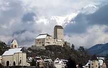
Sargans is known for its castle, which dates from before the founding of the Swiss Confederation in 1291. Sargans was also a County of the Holy Roman Empire; see County of Sargans.
History
Sargans is first mentioned in 765 as de Senegaune though this comes from a 16th Century copy of the original. In 1248 it was mentioned as Sanegans, in 1264 as Sangans and in 1332 as Santgans. It was first recorded as Sargans in the late 16th century.[3]
Sargans was an independent county from the 11th century until 1798, when it was incorporated in the Canton of Linth of the Helvetic Republic, and eventually in the Canton of St. Gallen in 1803.
Geography

Sargans has an area, as of 2006, of 9.5 km2 (3.7 sq mi). Of this area, 38.4% is used for agricultural purposes, while 35.2% is forested. Of the rest of the land, 20.2% is settled (buildings or roads) and the remainder (6.2%) is non-productive (rivers or lakes).[4]
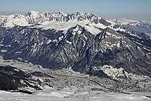
The municipality is the capital of the Sarganserland Wahlkreis. It is located at the foot of the Mt Gonzen. The eastern border of the municipality is the Rhine river and Liechtenstein. As it is located at the intersection of the Rhine and Seez valleys, Sargans has long been important in both a strategic and commercial sense. It consists of the village of Sargans and the hamlets of Vild, Ratell, Prod, Splee, Riet, Farb, Töbeli and Schwefelbad.
Transportation
The municipality is located on the A3 motorway. Transportation-wise, Sargans is an important regional node. Trains heading north toward St. Gallen, east toward Chur and Ticino, and toward Austria, all pass through Sargans. Buses heading toward Liechtenstein also leave Sargans.
Coat of arms
The blazon of the municipal coat of arms is Sable a Goose passant Argent langued beaked and membered Gules. This is an example of false canting. The goose German: Gans is not the origin of the name Sargans, rather it comes from a field named Senegaunis or in Romansh Sanagazza.[5]
Demographics
Sargans has a population (as of 31 December 2013) of 5,964.[2] As of 2007, about 22.0% of the population was made up of foreign nationals. Of the foreign population, (as of 2000), 34 are from Germany, 126 are from Italy, 432 are from former Yugoslavia, 38 are from Austria, 50 are from Turkey, and 228 are from other countries.[6] Over the last 10 years the population has grown at a rate of 7.3%. Most of the population (as of 2000) speaks German (87.0%), with Serbo-Croatian being second most common ( 3.2%) and Italian being third ( 2.1%).[4] Of the Swiss national languages (as of 2000), 4,146 speak German, 18 people speak French, 102 people speak Italian, and 22 people speak Romansh.[7]
The age distribution, as of 2000, in Sargans is; 522 children or 11.0% of the population are between 0 and 9 years old and 592 teenagers or 12.4% are between 10 and 19. Of the adult population, 594 people or 12.5% of the population are between 20 and 29 years old. 749 people or 15.7% are between 30 and 39, 738 people or 15.5% are between 40 and 49, and 610 people or 12.8% are between 50 and 59. The senior population distribution is 456 people or 9.6% of the population are between 60 and 69 years old, 339 people or 7.1% are between 70 and 79, there are 139 people or 2.9% who are between 80 and 89, and there are 26 people or 0.5% who are between 90 and 99.[7]
In 2000 there were 654 persons (or 13.7% of the population) who were living alone in a private dwelling. There were 1,108 (or 23.3%) persons who were part of a couple (married or otherwise committed) without children, and 2,555 (or 53.6%) who were part of a couple with children. There were 267 (or 5.6%) people who lived in single parent home, while there are 27 persons who were adult children living with one or both parents, 25 persons who lived in a household made up of relatives, 19 who lived household made up of unrelated persons, and 110 who are either institutionalized or live in another type of collective housing.[7]
In the 2007 federal election the most popular party was the SVP which received 35.2% of the vote. The next three most popular parties were the CVP (21.7%), the SP (19.4%) and the FDP (13.5%).[4]
In Sargans about 68.8% of the population (between age 25-64) have completed either non-mandatory upper secondary education or additional higher education (either university or a Fachhochschule).[4] Out of the total population in Sargans, as of 2000, the highest education level completed by 1,079 people (22.6% of the population) was Primary, while 1,870 (39.2%) have completed their secondary education, 477 (10.0%) have attended a Tertiary school, and 236 (5.0%) are not in school. The remainder did not answer this question.[7]
The historical population is given in the following table:[3]
| year | population |
|---|---|
| 1800 | 680 |
| 1850 | 907 |
| 1900 | 931 |
| 1950 | 2,075 |
| 1960 | 2,571 |
| 1970 | 4,058 |
| 2000 | 4,765 |
Religion

From the 2000 census, 3,001 or 63.0% are Roman Catholic, while 843 or 17.7% belonged to the Swiss Reformed Church. Of the rest of the population, there are 4 individuals (or about 0.08% of the population) who belong to the Christian Catholic faith, there are 132 individuals (or about 2.77% of the population) who belong to the Orthodox Church, and there are 53 individuals (or about 1.11% of the population) who belong to another Christian church. There are 4 individuals (or about 0.08% of the population) who are Jewish, and 265 (or about 5.56% of the population) who are Islamic. There are 75 individuals (or about 1.57% of the population) who belong to another church (not listed on the census), 218 (or about 4.58% of the population) belong to no church, are agnostic or atheist, and 170 individuals (or about 3.57% of the population) did not answer the question.[7]
Economy
As of 2007, Sargans had an unemployment rate of 1.75%. As of 2005, there were 79 people employed in the primary economic sector and about 29 businesses involved in this sector. 1,171 people are employed in the secondary sector and there are 58 businesses in this sector. 1,791 people are employed in the tertiary sector, with 218 businesses in this sector.[4]
As of October 2009 the average unemployment rate was 3.9%.[8] There were 310 businesses in the municipality of which 57 were involved in the secondary sector of the economy while 227 were involved in the third.[9]
As of 2000 there were 994 residents who worked in the municipality, while 1,493 residents worked outside Sargans and 1,893 people commuted into the municipality for work.[10]
Heritage sites of national significance
Both the local mining operation and Schloss Sargans are listed as Swiss heritage sites of national significance.[11]
Weather
Sargans has an average of 142.2 days of rain or snow per year and on average receives 1,325 mm (52.2 in) of precipitation. The wettest month is August during which time Sargans receives an average of 153 mm (6.0 in) of rain or snow. During this month there is precipitation for an average of 14.3 days. The month with the most days of precipitation is June, with an average of 14.5, but with only 136 mm (5.4 in) of rain or snow. The driest month of the year is October with an average of 82 mm (3.2 in) of precipitation over 14.3 days.[12]
References
- ↑ Arealstatistik Standard - Gemeindedaten nach 4 Hauptbereichen
- ↑ 2.0 2.1 Swiss Federal Statistics Office – STAT-TAB Ständige und Nichtständige Wohnbevölkerung nach Region, Geschlecht, Nationalität und Alter (German) accessed 18 August 2014
- ↑ 3.0 3.1 Sargans in German, French and Italian in the online Historical Dictionary of Switzerland.
- ↑ 4.0 4.1 4.2 4.3 4.4 Swiss Federal Statistical Office accessed 6 January 2010
- ↑ Flags of the World.com accessed 6 January 2010
- ↑ Der Kanton St. Gallen und seine Menschen in Zahlen - Ausgabe 2009 (German) accessed 30 December 2009
- ↑ 7.0 7.1 7.2 7.3 7.4 Canton St. Gallen Statistics-Hauptergebnisse der Volkszählung 2000: Regionen- und Gemeindevergleich-Personen (German) accessed 30 December 2009
- ↑ St Gallen Canton statistics-Unemployment (German) accessed 30 December 2009
- ↑ St Gallen Canton statistics-Businesses (German) accessed 31 December 2009
- ↑ St Gallen Canton statistics-Commuters (German) accessed 31 December 2009
- ↑ Swiss inventory of cultural property of national and regional significance 21.11.2008 version, (German) accessed 06-Jan-2010
- ↑ "Temperature and Precipitation Average Values-Table, 1961-1990" (in German, French, and Italian). Federal Office of Meteorology and Climatology - MeteoSwiss. Retrieved 8 May 2009., the weather station elevation is 487 meters above sea level.
External links
| Wikimedia Commons has media related to Sargans. |
- (German) Official website
| ||||||||