Saraj Municipality
Municipality of Saraj
Општина Сарај
Komuna e Sarajit |
|---|
|
Rural municipality |
Flag | 
Coat of arms | |
 |
| Country |
Macedonia |
|---|
| Municipal seat |
Saraj (Skopje) |
|---|
| Government |
|---|
| • Mayor |
Bekim Murati (DUI) |
|---|
| Area |
|---|
| • Total |
229.06 km2 (88.44 sq mi) |
|---|
| Population |
|---|
| • Total |
35,408 |
|---|
| Time zone |
CET (UTC+1) |
|---|
| Website |
http://www.saraj.gov.mk |
|---|
Saraj (Macedonian:  Сарај , Albanian: Saraj) is one of the ten municipalities that make up the city of Skopje, the capital of the Republic of Macedonia. Saraj, which means "palace" in Turkish, is also the name of the village where the municipal seat is found. It is a rural municipality and it is not part of Skopje proper.
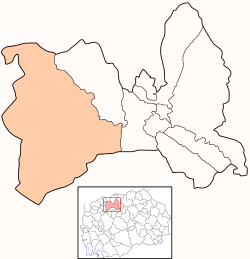
Geography
Saraj borders Jegunovce Municipality to the northwest, Želino Municipality to the southwest, Sopište Municipality to the south, Karpoš Municipality and Gjorče Petrov Municipality to the east, and Kosovo to the north.
Demographics
According to the last national census from 2002, Saraj has 35,408 inhabitants.[1] Ethnic groups in the municipality include:
- Albanians = 32,408 (91.5%)
- Macedonians = 1,377 (3.9%)
- Bosniaks = 1,120 (3.2%)
- others.
Twin towns
Twin municipalities
References
External links
|
|---|
| | Municipalities | | |
|---|
| | Geography | |
|---|
| | History | Timeline of Skopje history |
|---|
| | Landmarks | |
|---|
| | Churches | |
|---|
| | Museums | |
|---|
| | Sports venues | |
|---|
| | Sports clubs | |
|---|
| | Education | |
|---|
| | Events | |
|---|
| | Transportation | |
|---|
| | People | |
|---|
|
|
|---|
| | Municipalities | | |
|---|
| | Greater Skopje | |
|---|
| | Former |
- Bač
- Belčišta
- Bistrica
- Blatec
- Bogomila
- Capari
- Čegrane
- Češinovo
- Delogoždi
- Dobruševo
- Dolna Banjica
- Drugovo
- Džepčište
- Izvor
- Kamenjane
- Klečovce
- Kondovo
- Konopište
- Kosel
- Kukliš
- Kukurečani
- Labuništa
- Lukovo
- Mavrovi Anovi
- Mešeišta
- Miravci
- Murtuno
- Negotino-Pološko
- Obleševo
- Orašac
- Orizari
- Oslomej
- Podareš
- Rostuša
- Samokov
- Šipkovica
- Sopotnica
- Srbinovo
- Staravina
- Topolčani
- Velešta
- Vraneštica
- Vitolište
- Vratnica
- Vrutok
- Zajas
- Žitoše
- Zletovo
|
|---|
|
|
|---|
| | | | | The municipality names in italics have an Albanian population of over 50% but below 60%. Names in brackets are Albanian equivalents of the Macedonian names. |
|
Coordinates: 42°00′01″N 21°19′29″E / 42.0004°N 21.3248°E / 42.0004; 21.3248