Sapinero, Colorado
| Sapinero, Colorado | |
|---|---|
| Unincorporated community | |
|
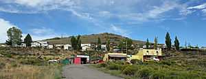
Sapinero in 2014. | |
 Location in Gunnison County and the state of Colorado | |
| Coordinates: 38°27′35″N 107°18′12″W / 38.45972°N 107.30333°WCoordinates: 38°27′35″N 107°18′12″W / 38.45972°N 107.30333°W | |
| Country |
|
| State |
|
| County | Gunnison County[1] |
| Elevation[1] | 7,621 ft (2,323 m) |
| Time zone | MST (UTC-7) |
| • Summer (DST) | MDT (UTC-6) |
| ZIP code[2] | 81247 (Gunnison) |
| Area code(s) | 970 |
| GNIS feature ID | 0188204 |
Sapinero is an unincorporated community located on U.S. Highway 50, along the shore of Blue Mesa Reservoir in the Curecanti National Recreation Area in Gunnison County, Colorado, United States. The U.S. Post Office at Gunnison (ZIP Code 81247) now serves Sapinero postal addresses.[2]
History
Sapinero's original location was on the north bank of the Gunnison River, just downstream from the mouth of Soap Creek, at approximately (38.47042, -107.30600), about one mile north of its current location. Sapinero was originally a stop on the Denver & Rio Grande Railroad's narrow gauge main line between Denver and Salt Lake City. Eventually, a standard gauge route supplanted the Gunnison line, and the narrow gauge's final abandonment came in 1955. In about 1963, when Blue Mesa Dam was built on the Gunnison River below Sapinero, the town was moved and re-established in its present location, prior to the area's inundation by the water of Blue Mesa Reservoir.
Climate
Climate type is dominated by the winter season, a long, bitterly cold period with short, clear days, relatively little precipitation mostly in the form of snow, and low humidity. The Köppen Climate Classification sub-type for this climate is "Dfc" (Continental Subarctic Climate).[3]
See also
References
- ↑ 1.0 1.1 "US Board on Geographic Names". United States Geological Survey. 2007-10-25. Retrieved 2008-01-31.
- ↑ 2.0 2.1 "ZIP Code Lookup" (JavaScript/HTML). United States Postal Service. January 3, 2007. Retrieved January 3, 2007.
- ↑ Climate Summary for Sapinero
| |||||||||||||||||||||
