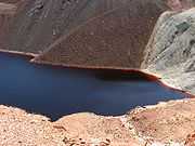
Sao Domingos Mine


The São Domingos Mine is a deserted open-pit mine in São Domingos, Alentejo, Portugal. This site is one of the volcanogenic massive sulfide ore deposits in the Iberian Pyrite Belt, which extends from the southern Portugal into Spain. The Romans mined in the São Domingos area for gold and silver for about 400 years. Mining stopped here when the Romans left.
In 1854 Nicolau Biava, an Italian miner from Piedmont, staked a claim to the mine; ownership then passed to a French syndicate. In 1855 mining was resumed, as the international demand for copper grew during the Industrial Revolution. In 1859 the mining concession was leased for 50 years to an English mining company, Mason and Barry, because of their industrial mining expertise. The nearby port of Pomarão was inaugurated the same year. Known as Pomaron in England, this inland port was specially constructed on the River Guadiana, which here forms the border with Spain, to serve the mine. In 1862 an 11-mile (18 km) railway, of three foot-six inch gauge, was opened connecting the mine to Pomarão. From Pomarão ore was exported, mostly to England, by ship. Pomarão was destroyed in a disastrous flood on 6–8 December 1876, and subsequently rebuilt.
Mason and Barry switched from tunnel mining to open-pit mining in 1867. Copper ore was the main product of the mine; in addition, pyrite was mined as a source of sulphur. About 25 megatons of ore had been extracted when the mine was closed in 1966.
Since closure the mine has attracted tourists. Many old mine buildings and the open-cast pit remain. The old mining company headquarters has been converted into a hotel. A small museum and archive, the casa do mineiro, in an old miner's cottage, depicts the life of the Portuguese miner. There is also an exhibition in an old cinema. There is an English cemetery, where mine managers and their families, many from Cornwall, are buried. The railway line has been removed but one can still see the trackbed for much of the route.
External links
- Instituto Gelogicao e Mineiro - Environmental State:Past and present
- geocaching.com - Mine description
- Society of Economic Geologists - Introduction to the Iberian Pyrite Belt