Santo Tomás, Chontales
| Santo Tomás | |
|---|---|
| Municipality | |
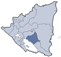
 Santo Tomás Location in Nicaragua | |
| Coordinates: 12°4′N 85°4′W / 12.067°N 85.067°W | |
| Country |
|
| Department | Chontales Department |
| Area | |
| • Total | 211.0 sq mi (546.6 km2) |
| Population (2005) | |
| • Total | 18,404 |
| • Density | 87/sq mi (34/km2) |
Santo Tomás is a municipality in the Chontales Department of Nicaragua. It is located 190 km (118 mi) from Managua and 40 km (25 mi) from Juigalpa on the road to Rama. The town itself is approximately 75 miles distance from Managua, Nicaragua.
The main economic activities are agriculture and livestock. Many of the businesses located in Santo Tomas consist of small stores owned by individuals that live next to their commercial properties.
Climate is generally hot and rainy. In the winter temperatures cool down to 70 degrees.
The population consists of 21,000 inhabitants. The majority of the people are Catholic.
In the center of town, there is a park and a Catholic church. There are private schools and public schools in the area. Students seeking continuing education must leave the town and attend the universities located in the capital.
Santo Tomás has a sister county association with Thurston County Washington through the Thurston Santo Tomás Sister County Association and a sister city relationship with Mol, Belgium.
For entertainment the people of Santo Tomas have a limited amount of options to pick from. Most of the youth in Santo Tomas rent movies or attend home parties or drinking fest by the local rivers.
Santo Tomas is a relatively safe town. The main highway to Rama is paved and has been recently rebuilt.
| |||||||||||||