Santo Antônio do Paraíso
| Flag | |
|---|---|
 | |
| Map | |
 | |
| Statistics | |
| State: | Paraná |
| Meso-region: | Norte Pioneiro Paranaense |
| Micro-Region: | Cornélio Procópio |
| Location: | 23.495/23° 29' 38" S lat. 50.6475/50° 38' 45" W long. |
| Area: | 165.904 km² |
| Population (2003): - Total - Change - Density | 2,945 - 17.75/km² |
| Postal code: | 86315-xxx |
| Website: | www.stoantonioparaiso.rs.gov.br |
Santo Antônio do Paraíso (first part, Portuguese meaning "Saint Anthony", last part meaning paradise) is a municipality of the state of Paraná, Brazil. Its area is 165.904 km² and its population was 2,945 in 2003.
Coat of arms
Its coat of arms features a blue shield with two keys with the letter t in the middle. The tag is at the bottom, its leaves are at the left and right and the crown coloured with gold and red at the top.
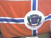
Flag
Its flag is red, white and blue with its coat of arms in the middle-right
External links
- http://www.citybrazil.com.br/rs/stoantonioparaiso/ (Portuguese)
- Map and Aerial photos:
- Coordinates: 23°29′38″S 50°38′45″W / 23.49389°S 50.64583°W
- Street maps: Street map from Mapquest, MapPoint or Google
- Satellite images and Aerial photos: Google