Santo Antônio das Missões
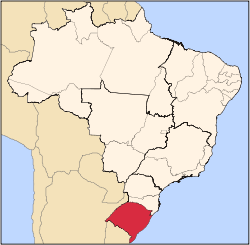
| Map | |
|---|---|
 | |
| Statistics | |
| State: | Rio Grande do Sul |
| Meso-region: | Northwestern Rio Grande do Sul (Noroeste Rio-Grandense) |
| Micro-Region: | Santo Ângelo |
| Founded: | October 12, 1965 |
| Location: | 28.51/28° 30' 39" S lat. 39.327/39° 13' 40" W long. |
| Area: | 1,714.239 km² |
| Population (2006): - Total - Change - Density | 12,496 7.3/km² |
| Elevation: | 213 m |
| Postal code: | 97870-xxx |
Santo Antônio das Missões (first part, Portuguese meaning "Saint Anthony", last part meaning mission) is a municipality in the western part of the state of Rio Grande do Sul, Brazil. Its coordinates are 6.867/6° 52' 8" S and the longitude is 42.35933/42° 21' 36" W. It has 2,060 inhabitants and the area is 32.596 km². Its density is 61.48/km² (2006). Distance from the state capital of Porto Alegre is 534 km west and tens of kilometres east from the Argentine border but the municipality does not border since it is close.
Bounding municipalities
External links
- Granizo gigante de 20 de outubro de 2007
- http://www.citybrazil.com.br/rs/stoantoniomissoes/ (Portuguese)
- Map and Aerial photos:
- Coordinates: 28°30′59″S 55°13′40″W / 28.51639°S 55.22778°W
- Street maps: Street map from Mapquest, MapPoint or Google
- Satellite images and Aerial photos: Google
