Santa Rosa de Copán
| Santa Rosa de Copán | |
|---|---|
|
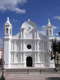
Church in Santa Rosa | |
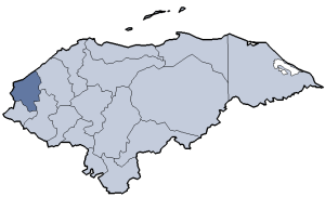
 Santa Rosa de Copán Location in Honduras | |
| Coordinates: 14°46′N 88°47′W / 14.767°N 88.783°W | |
| Country | Honduras |
| Department | Copán |
| Established as city | 12 April 1843 |
| Population | |
| • Total | 42,803 |
Santa Rosa de Copán (Spanish pronunciation: [ˈsanta ˈrosa ðe koˈpan]) is the departmental capital of the Honduran department of Copán. It is approximately 1,150 metres (3,773 ft) above mean sea level.
Santa Rosa de Copán, Honduras, is the largest and most important city in western Honduras with a population of 42,803. Santa Rosa is the governmental hub of the department of Copán. The city is connected through the International Highway of the West (CA-4) with San Pedro Sula to the North and with the borders of El Salvador at El Poy and Guatemala at Agua Caliente to the west. Santa Rosa has a subtropical climate with temperatures ranging from 25 °C (77 °F) to 29 °C (84 °F) in the summer (March–June), and from 13 °C (55 °F) to 15 °C (59 °F) in the winter (December–February).
The historical center of Santa Rosa de Copán has been declared a Honduran national monument, with preservation of its Republican or Neoclassical architecture and cobblestone streets that has its origins in a prosperous tobacco farming industry of the 18th century. Santa Rosa is situated at a strategic point between Copán Ruinas and Gracias, Lempira, and the Celaque National Park. As before, tobacco farming remains a staple of the local economy, particularly the cultivation of premium cigar tobaccos. The La Flor de Copán cigar factory is located in the city.
History
The city was founded in the early 18th century. 1705. on 8 August of that year. Mr. Captain Don Juan García de la Candelaria place to purchase the Spanish crown and founded his estate with four ranches; settlers at the site called "Los Llanos",later the first settlers named out as Santa Rosa, and later as Santa Rosa de Los Llanos;An industry of Tobacco was develop in early 18th Century and was picked as the site for La Real Factoria del Tabacos, the Royal Tobacco Company a Spanish crown company in 1765. Later, the province of Gracias a Dios was split in two departments, becoming Copán and Lempira. 1862. (May 7) As the nation's President Mr. Don Victoriano Castellanos Cortes, issued the Legislative Decree No. 3 in which is given the title of "REPUBLIC OF HONDURAS" to our country, therefore, no longer called "State of Honduras." In 1865, it was renamed Santa Rosa de Copan.
Climate
Santa Rosa has a subtropical highland climate under the Köppen climate classification.
| Climate data for Santa Rosa, Honduras | |||||||||||||
|---|---|---|---|---|---|---|---|---|---|---|---|---|---|
| Month | Jan | Feb | Mar | Apr | May | Jun | Jul | Aug | Sep | Oct | Nov | Dec | Year |
| Average high °C (°F) | 22.1 (71.8) |
23.9 (75) |
26.5 (79.7) |
28.1 (82.6) |
28.1 (82.6) |
26.6 (79.9) |
25.5 (77.9) |
25.8 (78.4) |
25.7 (78.3) |
24.1 (75.4) |
22.7 (72.9) |
21.9 (71.4) |
25.08 (77.16) |
| Daily mean °C (°F) | 17.6 (63.7) |
18.4 (65.1) |
20.4 (68.7) |
21.5 (70.7) |
21.9 (71.4) |
21.5 (70.7) |
21.0 (69.8) |
21.2 (70.2) |
21.0 (69.8) |
19.9 (67.8) |
18.7 (65.7) |
17.9 (64.2) |
20.08 (68.15) |
| Average low °C (°F) | 13.3 (55.9) |
12.9 (55.2) |
13.8 (56.8) |
15.0 (59) |
16.2 (61.2) |
17.4 (63.3) |
17.0 (62.6) |
17.1 (62.8) |
17.2 (63) |
16.4 (61.5) |
15.0 (59) |
13.9 (57) |
15.43 (59.78) |
| Average precipitation mm (inches) | 39.9 (1.571) |
29.2 (1.15) |
24.1 (0.949) |
43.6 (1.717) |
153.5 (6.043) |
288.4 (11.354) |
210.7 (8.295) |
215.8 (8.496) |
295.6 (11.638) |
145.1 (5.713) |
76.3 (3.004) |
58.4 (2.299) |
1,580.6 (62.229) |
| Avg. rainy days | 6 | 5 | 3 | 4 | 9 | 16 | 15 | 15 | 16 | 12 | 9 | 8 | 118 |
| Source: HKO[1] | |||||||||||||
Sports
Football club Deportes Savio has been playing in the Honduran National league since 2007 and play their home matches at the Estadio Sergio Antonio Reyes.
References
- ↑ "Climatological Normals of Santa Rosa". Hong Kong Observatory. Retrieved 2012-03-13.
External links
Coordinates: 14°46′N 88°47′W / 14.767°N 88.783°W
| |||||||||||||