Santa Maria de Jetibá
Coordinates: 20°02′27″S 40°44′45″W / 20.04083°S 40.74583°W
| Santa Maria de Jetibá | |||
|---|---|---|---|
|
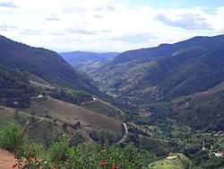
Canaan Valley, a Valley near of this town | |||
| |||
| Nickname(s): East Pomeranian Brazilian People | |||
| Country | Brazil | ||
| Region | Southeast | ||
| State | State of Espírito Santo | ||
| Founded | May 6, 1988 | ||
| Government | |||
| • Mayor | Eduardo Stuhr (PDT) | ||
| Area | |||
| • Total | 735.552 km2 (283.998 sq mi) | ||
| Elevation | 720 m (2,360 ft) | ||
| Population (2010)[1] | |||
| • Total | 37,720 | ||
| • Density | 51.319/km2 (132.92/sq mi) | ||
| Demonym | Santamariense | ||
| Time zone | UTC-3 (UTC-3) | ||
| • Summer (DST) | UTC-2 (UTC-2) | ||
| Website | Santa Maria de Jetibá City Hall | ||


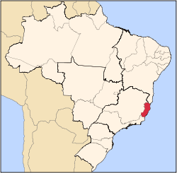
Santa Maria de Jetibá is the name of a municipality and of its capital in central Espírito Santo, Southeastern Brazil. It was founded in 1857 by Pomeranian immigrants who arrived through the state capital Vitória by going up the river Santa Maria.
Geography
Located in the south-central mountain region of Espírito Santo, this municipality has an area of 735.55 square kilometers. The town of Santa Maria de Jetibá is 720 meters above sea level, and the highest point in the state is Garrafão Peak, at 1200 meters (3937 ft) above sea level.
People
With a total population of 32,224 (2005),[2] Santa Maria de Jetibá is considered one of the last significant Pomeranian-Low-German-speaking communities in the world. Those immigrants (Pomeranians), who came from the historical region Pomerania, now part of Germany and Poland where it is known as Pommern and Pomorze respectively.
In Brazil, many Pomeranians also established communities in Santa Catarina (see Pomerode) and Rio Grande do Sul (see Arroio do Padre). Santa Maria de Jetibá is a place where the people still speak solely Pomeranian in their day-to-day life. Due to the isolation of this community, most of the members of the community live in very poor conditions. Due also to financial constraints by the state, very little investment in education is forthcoming, and the language barrier persists to be a real problem for the community. This also hinders their future prospects, of course, by them not having proper education, thus a reasonable expectation in the work market. Those communities are mainly rural.
Demography
Most of the population of that city is descended from Pomeranian and German peoples. [3][4]
| Race | Percentage |
|---|---|
| Whites | 81.8% |
| Blacks | 1.9% |
| Mixed | 15.6% |
| Asian | 0.7% |
Source: 2010 Census
Climate
Santa Maria de Jetibá is on a high valley and the altitude of this Town is about 700m above the sea level. The elevation of this municipality changes the climate and it features a cool and dry climate on winters and an wet and hot days and cool nights on summers. Santa Maria de Jetibá features an Humid Subtropical Climate type Cwa.
| Month | Jan | Feb | Mar | Apr | May | Jun | Jul | Aug | Sep | Oct | Nov | Dec | Year |
|---|---|---|---|---|---|---|---|---|---|---|---|---|---|
| Average high °C (°F) | 28.6 (83.5) |
28.3 (82.9) |
27.1 (80.8) |
25.5 (77.9) |
24.5 (76.1) |
23.7 (74.7) |
24.2 (75.6) |
24.6 (76.3) |
25.2 (77.4) |
26.0 (78.8) |
26.8 (80.2) |
26.1 (79) |
25.88 (78.6) |
| Average low °C (°F) | 18.0 (64.4) |
18.0 (64.4) |
16.8 (62.2) |
14.8 (58.6) |
13.0 (55.4) |
12.4 (54.3) |
12.9 (55.2) |
14.2 (57.6) |
15.5 (59.9) |
16.6 (61.9) |
17.4 (63.3) |
16.0 (60.8) |
15.47 (59.83) |
| Average precipitation mm (inches) | 188 (7.4) |
103 (4.06) |
125 (4.92) |
88 (3.46) |
60 (2.36) |
36 (1.42) |
49 (1.93) |
48 (1.89) |
66 (2.6) |
125 (4.92) |
193 (7.6) |
209 (8.23) |
1,290 (50.79) |
| Source: Clic RBS (Portuguese) [5] | |||||||||||||
See also
- Low German language
References
- ↑ http://www.ibge.gov.br/home/estatistica/populacao/estimativa2006/POP_2006_DOU.pdf
- ↑ IBGE -
- ↑ Santa Maria de Jetibá realiza a II PomerBR
- ↑ Santa Maria de Jetibá realiza 23ª Festa Pomerana
- ↑ Climate-data.org "Climatologia de Santa Maria de Jetibá - ES" (in Portuguese). Clic RBS. Retrieved 4 August 2011.
| |||||||||||||||||||||||||||||||||||||||||||||||||||||||||||||||||||||