Santa María de Jesús
| Santa María de Jesús Santa María de Jesús | |
|---|---|
| Municipality | |
| Santa María De Jesús | |
|
Volcán de Agua | |
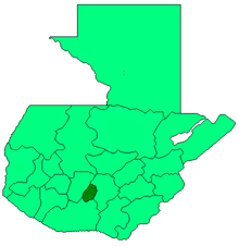
 Santa María de Jesús Location within Guatemala | |
| Coordinates: 14°29′36″N 90°42′34″W / 14.49333°N 90.70944°WCoordinates: 14°29′36″N 90°42′34″W / 14.49333°N 90.70944°W | |
| Country |
|
| Department |
|
| Fundación | 1816 |
| Government | |
| • Type | Municipality |
| • Mayor | Sotero Chunuj Reyes |
| Elevation | 2,070 m (6,790 ft) |
| Population (2002) | |
| • Total | 15,529 |
| Time zone | Central America (UTC-6) |
| Climate | Cwb |
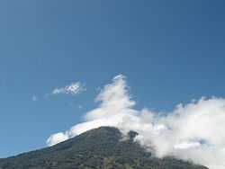
Santa Maria de Jesus (Spanish pronunciation: [ˈsanta maˈɾi.a ðe xeˈsus]) is a municipality in the department of Sacatepéquez about 10 km from the city of Antigua Guatemala. It is located under the slopes of Volcán de Agua. This town has a height of 2,070 meters above sea level. Its central square has a temple built in the seventeenth century with a carved entry arch. Spanish and Kaqchikel are spoken in this town.
History
There was no mention of it prior to the sixteenth century. One of the most important activities performed during the Hispanic period in this township was bringing ice gathered from the summit of Volcan de Aguato to the city of Santiago. The central square has a temple built in the seventeenth century with a carved entry arch.
Folklore
Among the folk dances presented in this municipality are the dance of "The Deer" and "Micos."