Santa María (volcano)
| Santa María, Santiaguito | |
|---|---|
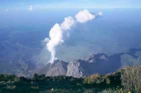 Santiaguito side cone from the summit of Santa María | |
| Elevation | 3,772 m (12,375 ft) |
| Location | |
 Santa María, Santiaguito Guatemala | |
| Location | Quetzaltenango Department, Guatemala |
| Range | Sierra Madre |
| Coordinates | 14°45′21.6″N 91°33′07.2″W / 14.756000°N 91.552000°WCoordinates: 14°45′21.6″N 91°33′07.2″W / 14.756000°N 91.552000°W |
| Geology | |
| Type | Stratovolcano |
| Volcanic arc/belt | Central America Volcanic Arc |
| Last eruption | 1922 to present |
Santa María Volcano is a large active volcano in the western highlands of Guatemala, in the Quetzaltenango Department near the city of Quetzaltenango.
The volcano was known by Gagxanul in the local K'iche' language, before the 16th century Spanish Conquest of the region.[1]
The eruption of Santa María Volcano in 1902 (VEI 6) was one of the three largest eruptions of the 20th century, after the 1912 Novarupta and 1991 Pinatubo eruptions. It is also one of the five biggest eruptions of the past 200 (and probably 300) years.[2]
Geological history
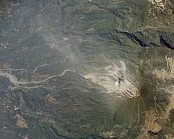
Santa María Volcano is part of the Sierra Madre range of volcanoes, which extends along the western edge of Guatemala, separated from the Pacific Ocean by a broad plain. The volcanoes are formed by the subduction of the Cocos Plate under the Caribbean Plate, which led to the formation of the Central America Volcanic Arc.
Eruptions at Santa María are estimated to have begun about 30,000 years ago. For several thousand years, eruptions seem to have been small and frequent, building up the large cone of the volcano, reaching about 1,400 metres (4,600 ft) above the plain on which the nearby city of Quetzaltenango sits. Following the cone-building eruptions, activity seems to have changed to a pattern of long periods of repose followed by the emission of small lava flows from vents on the mountain.
1902 eruption


The first eruption of Santa María in the recorded history occurred in October 1902. Before 1902 the volcano had been dormant for at least 500 years and possibly several thousand years, but its awakening was clearly indicated by a seismic swarm in the region starting in January 1902, which included a major earthquake in April 1902. The eruption began on 24 October, and the largest explosions occurred over the following two days, ejecting an estimated 5.5 cubic kilometres (1.3 cu mi) of magma. The eruption was one of the largest of the 20th century, only slightly less in magnitude to that of Mount Pinatubo in 1991. The eruption had a VEI of 6, thus being 'Colossal'.[3]
The pumice formed in the climactic eruption fell over an area of about 273,000 square kilometres (105,000 sq mi), and volcanic ash was detected as far away as San Francisco, 4,000 kilometres (2,500 mi) away. The eruption tore away much of the south-western flank of the volcano, leaving a crater about 1 kilometre (0.6 mi) in diameter and about 300 metres (980 ft) deep, stretching from just below the summit to an elevation of about 2,300 metres (7,500 ft). The first evidence of the eruption was a sprinkling of sand on Quezaltenango. The wind then changed from the south to the east and ashes began to fall at Helvetia, a coffee plantation six miles to the South-West.[4]
Because of the lack[3] of previous Holocene activity at Santa María, local people did not recognise the preceding seismicity as warning signs of an eruption. At least 5,000 people died as a result of the eruption itself, and a subsequent outbreak of malaria killed many more.
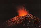
Santiaguito
The 1902 eruption was followed by 20 years of dormancy. In 1922, new eruptions began, with the extrusion of a lava dome in the crater left by the 1902 eruption. The lava dome was dacitic in composition[5]
The dome growth has been both 'exogenous and endogenous. Activity has been concentrated at several different vents, and Santiaguito now has the appearance of several overlapping domes. The currently active vent is El Caliente.[5] There are three other domes - El Brujo, El Mitad and El Monje.[6]
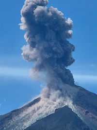
Although most of Santiaguito's eruptive activity has been relatively gentle, occasional larger explosions have occurred. In 1929, part of the dome collapsed, generating pyroclastic flows which killed anywhere from several hundred up to 5,000 people.[7] Occasional rockfalls have generated smaller pyroclastic flows, and vertical eruptions of ash to heights of a few kilometres above the dome are common.
Volcanic hazards at Santa María
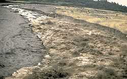
The areas to the south of Santa María are considerably affected by volcanic activity at Santiaguito. Currently, the most common volcanic hazards at Santa María are lahars, which frequently occur in the rainy season due to heavy rainfall on loose volcanic deposits. The town of El Palmar, 10 kilometres (6 mi) from Santiaguito, has been destroyed twice by lahars from Santiaguito forcing the town to be moved to the present Nuevo El Palmar, and infrastructure such as roads and bridges have been repeatedly damaged. Lahar deposits from Santiaguito have affected rivers all the way downstream to the Pacific Ocean.
Lava flows do not occur frequently from Santiaguito, and tend to stretch no more than a few kilometres from the dome. The magma at Santiaguito is rich in silica and is thus highly viscous. Lava flows are therefore slow-moving and are of little danger to human life, although property damage may occur. Fast-moving pyroclastic flows can occur, and these may travel several kilometres from the dome.
One hazard which could be devastating is the collapse of Santa María itself. The 1902 crater has left the southern flank of the mountain above Santiaguito highly over-steepened, and a large earthquake or eruption from Santiaguito could trigger a huge landslide, which might cover up to 100 square kilometres (39 sq mi). However, this is thought to be unlikely in the short term.
In light of the threat it poses to nearby populations, Santa María has been designated a Decade Volcano, identifying it as a target for particular study by volcanologists to mitigate any future natural disasters at the volcano.
See also
- List of volcanoes in Guatemala
- List of volcanic eruptions by death toll
- Timetable of major worldwide volcanic eruptions
References
- Notes
- ↑ Recinos 1952, 1986, p.69.
- ↑ "Large Holocene Eruptions". Global Volcanism Program. Smithsonian Institution. Retrieved 12 October 2008.
- ↑ 3.0 3.1 http://www.volcano.si.edu/world/volcano.cfm?vnum=1402-03=&volpage=erupt
- ↑ Anderson, Tempest (1908). The Volcanoes of Guatemala. London: The Royal Geographical Society. p. 478.
- ↑ 5.0 5.1 http://www.volcano.si.edu/world/volcano.cfm?vnum=1402-03=
- ↑ http://www.volcano.si.edu/world/volcano.cfm?vnum=1402-03=&volpage=synsub
- ↑ Sapper & Termer, 1930
- Bibliography
- Bunzendahl, E.; Bluth, G. J.; Rose, W. I.; Reif, S. L.; Matias, O. (2001), Developing a Long-term Hazard Mitigation Plan for Consequent Volcanic Sedimentation Hazards at Santiaguito Dome Complex, Guatemala, American Geophysical Union, Fall Meeting 2001, abstract #V41A-0974
- Harris, A. J.; Flynn, L. P.; Rose, W. I.; Matias, O.; Cornejo, J. (2002), The extrusion of lava dome and block lava flow units at Santiaguito, 1922-2002, American Geophysical Union, Fall Meeting 2002, abstract #V12A-1399
- Recinos, Adrian (1986). Pedro de Alvarado: Conquistador de México y Guatemala (in Spanish) (2nd ed.). Guatemala: CENALTEX Centro Nacional de Libros de Texto y Material Didáctico "José de Pineda Ibarra". OCLC 243309954.
- Sapper, K.; F. Termer (1930). "Der Ausbruch des Vulkans Santa María in Guatemala vom 2–4 November 1929". Zeitschrift fur Vulkanologie 13 (73).
External links
- "Santa Maria". Global Volcanism Program. Smithsonian Institution.
- Santa María: Pictures and recent activity, from VolcanoWorld
- Santa María Decade Volcano information
- Account of a visit to the Santiaguito Volcano Observatory at the Magma Cum Laude blog
| Wikimedia Commons has media related to Santa María Volcano. |
| |||||||||||||||||||||||||||||