Santa Luzia (Angra do Heroísmo)
| Santa Luzia | ||
| Civil Parish | ||
|
||
| Official name: Freguesia de Santa Luzia | ||
| Name origin: Portuguese for Saint Lucy | ||
| Country | ||
|---|---|---|
| Autonomous Region | ||
| Island | Terceira | |
| Municipality | Angra do Heroísmo | |
| Center | Santa Luzia | |
| - elevation | 89 m (292 ft) | |
| - coordinates | 38°39′39″N 27°13′22″W / 38.66083°N 27.22278°WCoordinates: 38°39′39″N 27°13′22″W / 38.66083°N 27.22278°W | |
| Highest point | Farrouco | |
| - elevation | 198 m (650 ft) | |
| - coordinates | 38°40′7″N 27°13′29″W / 38.66861°N 27.22472°W | |
| Lowest point | Sé | |
| - elevation | 38 m (125 ft) | |
| - coordinates | 38°39′22″N 27°13′25″W / 38.65611°N 27.22361°W | |
| Area | 1.26 km2 (0 sq mi) | |
| - urban | .66 km2 (0 sq mi) | |
| Population | 2,755 (2011) | |
| Density | 2,187 / km2 (5,664 / sq mi) | |
| Settlement | fl. 1595 | |
| - Parish | 18 August 1595 | |
| LAU | Junta Freguesia | |
| - location | Rua Dr. Eduardo Abreu | |
| President Junta | José Guilherme de Ávila Brasil (PS) | |
| President Assembleia | Manuel da Rocha Coelho de Melo (PS) | |
| Timezone | Azores (UTC-1) | |
| - summer (DST) | Azores (UTC0) | |
| Postal Zone | 9700-072 | |
| Area Code & Prefix | (+351) 292 XXX-XXXX | |
| Patron Saint | Santa Luzia | |
| Wikimedia Commons: Santa Luzia (Angra do Heroísmo) | ||
| Geographic detail from Instituto Geográfico Português (2010) | ||

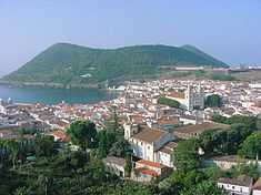
Santa Luzia (Portuguese for Saint Lucy) is a parish in the municipality of Angra do Heroísmo on the island of Terceira, in the Azores. The population in 2011 was 2,755,[1] in an area of 1.26 km².[2] It is the smallest parish in Angra do Heroísmo.
History
Of the five civil parishes that constitute the urban area of Angra do Heroísmo, Santa Luzia is the most recent, founded in the first years of the Iberian Union (in 18 August 1595).[3] It was Bishop Manuel de Gouveia (then bishop of Angra) who proposed the creation of the ecclesiastical parish from a portion of Sé, that included: the Rua de Paulus Gomes the two bands until the home of George de Lemos de Betancor, down to the fountain and forward to the house of the sheriff, from there to the Castle and from there to the Serra cut by the ravine and mills with all the residents that exist within those limits.[4] He justified it owing to the large faith community, the need to control transit on the island's port and the necessity to have access to health care services (at the time administered by the church).[5]
At the time of its creation the parish of Santa Luzia had only about 300 homes, with four per capita, the population only consisted of between 1200-1500 souls.[6] There already existed a hermitage to the invocation of Santa Luzia, simplifying the de-annexation of the parish; it was constructed originally by a pious couple at the limits of their property, João vaz Merens and Catarina Lourenço Fagundes, although their selection of Saint Lucia is unclear.[7]
In a documented dated in 1551, Joana Fernandes ou Rodrigues, a widow, donated lands in order to raise a church to Santa Luzia, reformulate or expand the existing hermitage (ostensibly for the founders and not for a future church) at the end of the 16th century.[8]
References
- Notes
- Sources
- Mota, Valdemar (2 February 1995), "Quatrocentos Anos de Santa Luzia de Angra", Boletim da Instituto Histórico da Ilha Terceira (in Portuguese), Angra do Heroísmo (Azores), Portugal: Instituto Histórico da Ilha Terceira (IHIT), pp. 71–91, retrieved 24 June 2011