Santa Fe, Cebu
| Santa Fe | ||
|---|---|---|
| Municipality | ||
|
Og-tong beach area Pooc, also showing Mayet and Yooneek resorts | ||
| ||
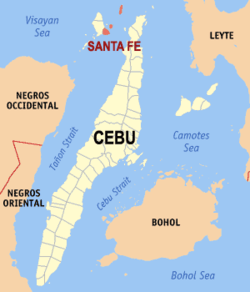
 Map of Cebu with Santa Fe highlighted | ||
.svg.png) Santa Fe Location within the Philippines | ||
| Coordinates: 11°09′N 123°49′E / 11.15°N 123.82°ECoordinates: 11°09′N 123°49′E / 11.15°N 123.82°E | ||
| Country | Philippines | |
| Region | Central Visayas (Region VII) | |
| Province | Cebu | |
| District | 4th District of Cebu | |
| Barangay | 10 (see § Barangays) | |
| Government[1] | ||
| • Type | Sangguniang Bayan | |
| • Mayor | Jose Esgana (1‑Cebu) | |
| • Vice mayor | Celso Espinosa | |
| • Town Council |
Members
| |
| Area[2] | ||
| • Total | 28.05 km2 (10.83 sq mi) | |
| Population (2010)[3] | ||
| • Total | 27,270 | |
| • Density | 970/km2 (2,500/sq mi) | |
| • Voters (2013)[4] | 15,682 | |
| Demonym | Santafehanon | |
| Time zone | PST (UTC+8) | |
| ZIP code | 6047 | |
| IDD : | +63 (0)32 | |
| Income class | 4th class | |
| PSGC | 072244000 | |
Santa Fe is a fourth income class municipality in the province of Cebu, Philippines.[5]According to the 2010 census, it has a population of 27,270.[3] In the last election, it had 15,682 registered voters.[4]
The municipality's territory occupies the southeastern portion of Bantayan Island (marching with the municipality of Bantayan), together with the islands of Guintacan (or Kinatarkan), Hilantagaan and Hilantagaan Diot. Because the island's airport and principal ferry port are both located within the municipality, Santa Fe is considered the gateway to Bantayan and its islands.
Transport
Bantayan Airport, serving the whole Bantayan Island, is located in Santa Fe, although there are no scheduled flights. The town can also be reached by ferry from Hagnaya Wharf in San Remigio, Cebu.
Demographics
| Population census of Santa Fe | ||
|---|---|---|
| Year | Pop. | ±% p.a. |
| 1990 | 20,838 | — |
| 1995 | 21,720 | +0.78% |
| 2000 | 22,956 | +1.19% |
| 2007 | 26,826 | +2.17% |
| 2010 | 27,270 | +0.60% |
| Source: National Statistics Office[3][6] | ||
In the last election, it had 15,682 registered voters, meaning that 58% of the population are aged 18 and over.[4]
Barangays
Santa Fe comprises 10 barangays:
|
| ||||||||||||||||||||||||||||||||||||||||||||||||||||||||||||||
Economy
Although there is some small-scale industry, the municipality's principal source of income is fishing and agriculture, and from holidaymakers who come in large numbers, most notably during Holy Week, to enjoy the particularly fine white sand and uncrowded beaches.
Image gallery
-
Boat beached in Santa Fe
-

Guintacan Island; the 3 barangays of Hagdan, Kinatarkan and Langub are located on this island.
-
Ferry pier, Santa Fe
Notes
- ↑ 1.0 1.1 1.2 The island of Guinatacan comprises the three barangays Hagdan, Kinatarkan, and Langub
- ↑ Barangay comprises the islands of Hilantagaan and Hilantagaan Diot
References
- ↑ "Municipalities". Quezon City, Philippines: Department of the Interior and Local Government. Retrieved 8 April 2013.
- ↑ "Province: Cebu". PSGC Interactive. Makati City, Philippines: National Statistical Coordination Board. Retrieved 8 April 2013.
- ↑ 3.0 3.1 3.2 3.3 "Total Population by Province, City, Municipality and Barangay: as of May 1, 2010" (PDF). 2010 Census of Population and Housing. National Statistics Office. Retrieved 1 April 2013.
- ↑ 4.0 4.1 4.2 "2013 National and Local Elections Statistics". Commission on Elections. 2013.
- ↑ Philippine Income Classification for Provinces, Cities and Municipalities
- ↑ 6.0 6.1 "Population and Annual Growth Rates by Province, City and Municipality: Central Visayas: 1995, 2000 and 2007" (PDF). National Statistics Office. Archived from the original (PDF) on 24 June 2011.
| Wikimedia Commons has media related to Santa Fe, Cebu. |
 |
Visayan Sea |  | ||
| Bantayan | |
Tañon Strait | ||
| ||||
| | ||||
| Tañon Strait | ⛴ Hagnaya Bay | San Remigio |
| ||||||||||||||||||


