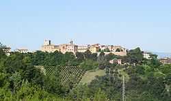
Sant'Angelo in Lizzola
| Sant'Angelo in Lizzola | |
|---|---|
| Comune | |
| Former Comune di Sant'Angelo in Lizzola | |
 | |
 Sant'Angelo in Lizzola Location of Sant'Angelo in Lizzola in Italy | |
| Coordinates: 43°50′N 12°48′E / 43.833°N 12.800°ECoordinates: 43°50′N 12°48′E / 43.833°N 12.800°E | |
| Country | Italy |
| Region | Marche |
| Province | Province of Pesaro e Urbino (PU) |
| Frazioni | Montecchio |
| Area | |
| • Total | 11.8 km2 (4.6 sq mi) |
| Population (Dec. 2004)[1] | |
| • Total | 7,617 |
| • Density | 650/km2 (1,700/sq mi) |
| Demonym | Santangiolesi |
| Time zone | CET (UTC+1) |
| • Summer (DST) | CEST (UTC+2) |
| Postal code | 61020 |
| Dialing code | 0721 |
| Patron saint | St. Michael Archangel |
| Saint day | May 8 |
| united to Colbordolo 1 january 2014 | |
Sant'Angelo in Lizzola was a comune (municipality) in the province of Pesaro e Urbino in the Italian region Marche, disbanded in 2014[2] and united to Colbordolo, after 76.3 percent of the population approved the unification in a referendum.
The resulting municipality was called Comune di Vallefoglia, with the town hall in Sant'Angelo in Lizzola.
Until 2014, The former municipality of Sant'Angelo in Lizzola bordered the following municipalities: the former comune of Colbordolo, Monteciccardo, Montegridolfo, Montelabbate, Pesaro, Tavullia. It was composed by the capital Sant'Angelo in Lizzola and by the frazione of Montecchio, which is the seat of numerous industries of woodcraft and glassworks.
The town was originated by the union of Monte Sant'Angelo and Liciole (Lizzola) around the year 1000 AD. The burgh of Montecchio, next to the river Foglia, was annexed in 1389.
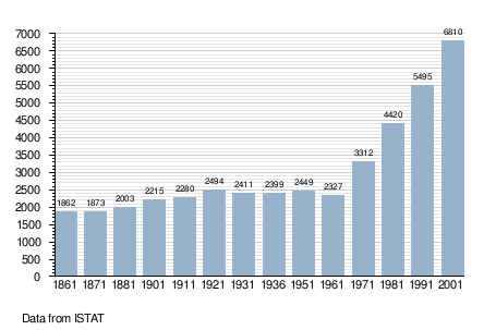
Demographic evolution