Sankt Peter, Baden-Württemberg
| St. Peter | ||
|---|---|---|
| ||
 St. Peter | ||
Location of St. Peter within Breisgau-Hochschwarzwald district 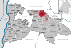
 | ||
| Coordinates: 48°0′59″N 8°1′57″E / 48.01639°N 8.03250°ECoordinates: 48°0′59″N 8°1′57″E / 48.01639°N 8.03250°E | ||
| Country | Germany | |
| State | Baden-Württemberg | |
| Admin. region | Freiburg | |
| District | Breisgau-Hochschwarzwald | |
| Government | ||
| • Mayor | Gottfried Rohrer (CDU) | |
| Area | ||
| • Total | 35.93 km2 (13.87 sq mi) | |
| Population (2012-12-31)[1] | ||
| • Total | 2,533 | |
| • Density | 70/km2 (180/sq mi) | |
| Time zone | CET/CEST (UTC+1/+2) | |
| Postal codes | 79271 | |
| Dialling codes | 07660 | |
| Vehicle registration | FR | |
| Website | www.st-peter-schwarzwald.de | |

Sankt Peter is a municipality in the district of Breisgau-Hochschwarzwald in Baden-Württemberg in Germany.
Gallery
-
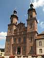
Sankt Peter, church: die Klosterkirche Sankt Peter und Paul
-
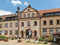
Sankt Peter, Kaufstätte Klosterhof
-

Sankt Peter, view to a street: die Steyrer Strasse
-
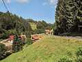
between Sankt Peter and Glottertal, road panorama
Data
Location
St. Peter is a climatic spa located within the Southern Black Forest Nature Park, on the southern flank of the Kandel, about 12 miles east of Freiburg im Breisgau.
Administrative structure
To the municipality of St. Peter belong the village Bürgerschaft, the hamlet Sägendobel, the localities Kandelberg, Neuwelt, Oberibental, Ränke, Rohr, Schmittenbach, Schönhöfe, Seelgut and Willmendobel as well as the farms Eckpeterhof, Langeck and Lindlehof.
References
- ↑ "Gemeinden in Deutschland mit Bevölkerung am 31.12.2012 (Einwohnerzahlen auf Grundlage des Zensus 2011)". Statistisches Bundesamt (in German). 12 November 2013.
External links
- (German) St. Peter: History and images
- (German) St. Peter