Sanduo Shopping District Station
Sanduo Shopping District Station 三多商圈站 | |
 | |
|---|---|
| Sanduo Shopping District Station Platform | |
| Location | |
| Municipality | Kaohsiung |
| District(s) | Lingya |
| Info | |
| Type | Underground |
| Platforms | One island platform |
| History | |
| Opened | March 9, 2008 |
| Rail services | |
| Line(s) | Red Line (R8) |
| Daily Ridership | 19,118 (Jan. 2011)[1] |
| Operator(s) | Kaohsiung Rapid Transit Corporation |
| Sanduo Shopping District Station | |||||||||||||
| Traditional Chinese | 三多商圈車站 | ||||||||||||
|---|---|---|---|---|---|---|---|---|---|---|---|---|---|
| Simplified Chinese | 三多商圈车站 | ||||||||||||
| |||||||||||||
The Kaohsiung MRT Sanduo Shopping District Station is a station on the Red Line in Lingya District, Kaohsiung, Taiwan. The station is named after the Sanduo Shopping District.
Station Overview
The station is a two-level, underground station with an island platform and seven exits.[2] It is 213 meters long and is located at the intersection of Zhongshan 2nd Rd. and Sanduo 3rd Rd.[3]
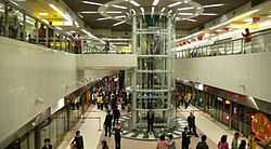
The station is unique in the Kaohsiung MRT for two reasons. First, it is the only underground station with an open platform, allowing for passengers to see the platform directly from the lobby area (similar to many underground stations on the Taipei Metro). The other is the unique design of the elevator; the structure is incorporated both into the lighting on the ceiling as well as the platform level.
Station layout
| Street Level | Entrance/Exit | Entrance/Exit |
| B1 | Concourse | Lobby, information desk, automatic ticket machines, one-way faregates |
| Restrooms (South side outside fare zone, near Exit 3), Underground mall | ||
| B2 | Platform 1 | ← KMRT Red Line toward Siaogang (Shihjia) |
| Platform 2 | → KMRT Red Line toward Gangshan South (Central Park) → | |
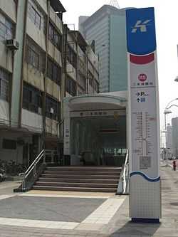
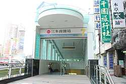
Exits
- Exit 1: Far Eastern Department Store, Tuntex Sky Tower
- Exit 2: Far Eastern Department Store
- Exit 3: Shihjia Park, Taixin Bank
- Exit 4: SOGO Department Store, Shin Kong Mitsukoshi Department Store
- Exit 5: Gas station
- Exit 6: Shengri Park, Lingya Junior High School
- Exit 7: Lingjhou Elementary School, Siwei Park
Around the Station
- Sanduo Shopping Circle
- Singuang Ferry Wharf
- Singuang Boulevard
- Shin Kong Mitsukoshi Department Store
- Pacific SOGO Department Store
- Tuntex Sky Tower
- Far Eastern Department Store, Vieshow Cinemas
- Wunheng Night Market
- Yisin Road
- Guangnan Sanduo Store
- Sanduo Cineplex
- Lingya Junior High School
- Lingjhou Elementary School
- Shihjia Park
- Shengrih Park (Birthday Park)
- Sihwei Park
- Chen Jhong-he Memorial Hall
Nearby stations
| Preceding station | Kaohsiung MRT | Following station | ||
|---|---|---|---|---|
toward Gangshan South | Red Line | toward Siaogang |
References
| Wikimedia Commons has media related to Sanduo Shopping District Station. |
- ↑ "統計資訊 > 統計月報". Transportation Bureau, Kaohsiung City Government. Retrieved 2011-02-15.
- ↑ "三多商圈站". 高雄捷運公司. Retrieved 2010-07-10.
- ↑ "三多商圈車站週邊地圖". 高雄市政府捷運工程局. Retrieved 2010-07-10.
Coordinates: 22°36′50″N 120°18′16.4″E / 22.61389°N 120.304556°E