Sand Springs, Montana
| Sand Springs, Montana | |
|---|---|
| Unincorporated community | |
|
Sand Springs Store in Sand Springs | |
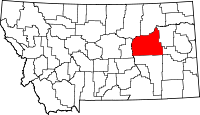
 Sand Springs, Montana Location within the state of Montana | |
| Coordinates: 47°6′3″N 107°29′8″W / 47.10083°N 107.48556°WCoordinates: 47°6′3″N 107°29′8″W / 47.10083°N 107.48556°W | |
| Country | United States |
| State | Montana |
| County | Garfield |
| Elevation | 3,192 ft (973 m) |
| Time zone | Mountain (MST) (UTC-7) |
| • Summer (DST) | MDT (UTC-6) |
| ZIP codes | 59077 |
| GNIS feature ID | 776203 |
Sand Springs is an unincorporated community in southwestern Garfield County, Montana, United States. It lies along Highway 200 southwest of the town of Jordan, the county seat of Garfield County.[1] Its elevation is 3,192 feet (973 m).[2] Although Sand Springs is unincorporated, it has a post office with the ZIP code of 59077,[3] which opened on 1911-03-01.[4] Sand Springs is over 100 years old, founded at the turn of the 20th century by sheep, cattle, and horse ranchers. It has a population of about 90 people. It gets its name from the wide expanse of sandy soil and life-giving springs in the area. Most people currently make a living as ranchers and farmers. The farmable acres in this area are some of the richest, most productive soils in the county; however much of the land is suitable only for grazing due to the terrain. There is a family-owned reservoir that is open to the public for fishing. The economy is supported by recreation -there is excellent hunting, fishing, and camping opportunities available all year round. Just check in at the Fish, Wildlife, and Parks station located in the center of town. There is a General Store attached to the Post Office. It has lunch available that you can eat at a picnic table. People are allowed to camp behind it. There is a church that has a service every other Sunday. It is the location of the annual Christmas program put on by the school. Sand Springs School is a one room schoolhouse that serves kindergarten through eighth grade.
Climate
According to the Köppen Climate Classification system, Sand Springs has a semi-arid climate, abbreviated "BSk" on climate maps.[5]
References
- ↑ Rand McNally. The Road Atlas '08. Chicago: Rand McNally, 2008, p. 61.
- ↑ U.S. Geological Survey Geographic Names Information System: Sand Springs, Montana
- ↑ Zip Code Lookup
- ↑ U.S. Geological Survey Geographic Names Information System: Sand Springs Post Office
- ↑ Climate Summary for Sand Springs, Montana
| |||||||||||||||||

