Sand Point and Middle Hope
| Site of Special Scientific Interest | |
 | |
 Shown within Somerset | |
| Area of Search | Avon |
|---|---|
| Grid reference | ST325662 |
| Coordinates | 51°23′27″N 2°58′17″W / 51.39081°N 2.97150°WCoordinates: 51°23′27″N 2°58′17″W / 51.39081°N 2.97150°W |
| Interest | Biological |
| Area | 84.1 hectares (0.841 km2; 0.325 sq mi) |
| Notification | 1952 |
| Natural England website | |
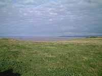
Sand Point in Somerset, England is the peninsula stretching out from Middle Hope, an 84.1 hectare biological and geological Site of Special Scientific Interest. It lies to the north of the village of Kewstoke, and the stretch of coastline called Sand Bay north of the town of Weston-super-Mare. On a clear day it commands views over Flat Holm, of the Bristol Channel, South Wales, Clevedon, the Second Severn Crossing and the Severn Bridge. A line drawn between Sand Point and Lavernock Point in South Wales marks the lower limit of the Severn Estuary and the start of the Bristol Channel.[1]
Middle Hope a sequence of Carboniferous Limestone with unusual geological features including a Pleistocene aged fossil cliff and as a result has been designated as a regionally important geological site. The underlying geology and soil types support scarce plants such as the Smallflower Buttercup, Honewort, Cheddar pink and Somerset Hair Grass.
Human use of the sites is shown by a bowl barrow and disc barrow from late Neolithic or Bronze Age and the site of a likely motte-and-bailey castle. Woodspring Priory, a former Augustinian priory which was founded in the early 13th century, sits just inland of the rocky promontory. The priory and surrounding land is owned by the National Trust and is a popular place for walking.
Geology
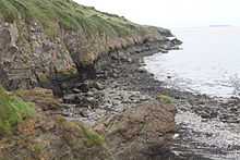
At Middle Hope a sequence of Carboniferous Limestone, and includes limestones, thick volcanic tuffs and lavas are exposed, affording some of the finest Tournaisian carbonate sections in South West England.[2] The site contains a Pleistocene aged fossil cliff and shore platform.[3][4][5] These features have lead to the designation of Middle Hope as a regionally important geological site (RIGS).[6]
The raised beach of wave cut platforms have been created by changes in sea level since the Quaternary period.[7][8] The arrangement of volcanic and sedimentary rocks, including the Black Rock Limestone illustrates the events of 350 million years ago (myr).[9][10] The strata have been tilted and compressed during the variscan orogeny.[6]
Flora
Among scarce plants found on Sand Point are Smallflower Buttercup,[11] and Honewort.[12] It is also the site of the Middle Hope 84.1 hectare biological and geological Site of Special Scientific Interest.[3] The range of soils at the site support various flora and fauna. The calcareous grassland is dominated by Festuca species and Dactylis glomerata, while the scrub towards the west of the site is dominated by Hawthorn (Crataegus monogyna) and Blackthorn (Prunus spinosa), while that to the east consists of Common Gorse (Ulex europaeus) and Bramble (Rubus fruticosus agg).[3] Less common plants include the Cheddar pink (Dianthus gratianopolitanus) and Somerset Hair Grass (Koeleria vallesiana).[13]
History
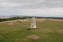
A bowl barrow and disc barrow from late Neolithic or Bronze Age have been identified. The bowl barrow is 10 metres (33 ft) in diameter and approximately 0.5 metres (1 ft 8 in) high. Slightly west of the bowl barrow is a disc barrow surrounded by a bank and ditch which enclose an area about 8 metres (26 ft) across. These are situated at the highest point where the Ordnance Survey have constructed a triangulation station.[14]
A motte-and-bailey castle may have been constructed after the Norman Conquest.[15] The sites is known as Castle Mound or Castle Batch and can be seen as a 2 metres (6 ft 7 in) high mound which is approximately 30 metres (98 ft) in diameter and marked by a ditch on the landward eastern edge.[16] The mound was damaged by the construction of a building during World War II. The medieval date for the construction is in doubt with some sources suggesting that the mound may have been a watchtower constructed in the 16th century.[17][18][19] The walls of the sheep fold were built by prisoners from the Napoleonic Wars.[18]
Woodspring Priory is a former Augustinian priory.[20] The priory was founded, by William de Courtney, in the early 13th century, and dedicated to Thomas Becket.[21] The small community built a church and monastic lodgings during the next hundred years. They were Victorine Canons who were influenced by the Cistercians who emphasised manual labour and self-sufficiency so that the clerks who had taken holy orders worked on the farm, as well as providing clergy for surrounding churches.[22] Despite endowments of land the priory was not wealthy until the 15th century when further building work, including the current priory church, infirmary and barn was undertaken. It was dissolved in 1536 and then owned by local noblemen and leased to local farmers.[23] In 1969 the priory was taken over by the Landmark Trust who spent 20 years on restoration work, and now rent out the farmhouse as holiday accommodation.[24] The surviving buildings include the priory church, which was a 15th-century replacement for the earlier 13th century structure, infirmary, barn and 16th century prior's lodging which was converted into a farmhouse. The whole site was arranged around a central cloister from which only the east wall and west wall of the chapter house remain, the sacristy, refectory, chapter house, lady chapel and parlour having been demolished.[25][26][27] In 1968 the priory and adjoining land of Middle Hope was purchased by the National Trust for Places of Historic Interest or Natural Beauty as part of Project Neptune.[28][29]
References
- ↑ "Severn Estuary". Severn Boating. Retrieved 15 December 2013.
- ↑ Prudden, Hugh. "Somerset Geology — A Good Rock Guide" (PDF). University of Bath. Bath Geological Society. Retrieved 8 March 2015.
- ↑ 3.0 3.1 3.2 "Middle Hope" (PDF). SSSI citation sheet. English Nature. Retrieved 31 October 2008.
- ↑ Faulkner, T.J. (1989). "The early Carboniferous (Courceyan) Middle Hope volcanics of Weston-super-Mare: development and demise of an offshore volcanic high". Proceedings of the Geologists' Association 100 (1): 93–106. doi:10.1016/S0016-7878(89)80068-9.
- ↑ "North Somerset Landscape Character Assessment" (PDF). North Somerset Council. Retrieved 8 March 2015.
- ↑ 6.0 6.1 "RIGS of the Month — March Middle Hope, Kewstoke, Somerset". Avon RIGS group. Retrieved 8 March 2015.
- ↑ "North Somerset Landscape Character Assessment" (PDF). North Somerset Council. Retrieved 14 July 2014.
- ↑ "Somerset". Natural England. Retrieved 14 July 2014.
- ↑ "Middle Hope, Kewstoke, Somerset". Avon RIGS Group. Retrieved 14 July 2014.
- ↑ "OGU fieldtrip to Middle Hope". University of Bristol. Retrieved 8 March 2015.
- ↑ Green, Ian P.; Higgins, Rupert J.; Kitchen, Mark A R.; Kitchen, C. (2000). Myles, Sarah L., ed. The Flora of the Bristol Region. Pisces Publications. p. 66. ISBN 978-1874357186.
- ↑ Green, Ian P.; Higgins, Rupert J.; Kitchen, Mark A R.; Kitchen, C. (2000). Myles, Sarah L., ed. The Flora of the Bristol Region. Pisces Publications. p. 161. ISBN 978-1874357186.
- ↑ "Search engine Bing uses Somerset’s iconic Sandpoint on homepage". Cheddar Valley Gazette. 12 October 2013. Retrieved 8 March 2015.
- ↑ "Bowl barrow and disc barrow 600 m NNW of Sandpoint Farm". National Heritage List for England. English Heritage. Retrieved 8 March 2015.
- ↑ "Motte and bailey castle 650 m NNW of Sandpoint Farm". National Heritage List for England. English Heritage. Retrieved 16 September 2014.
- ↑ "Monument No. 192646". Pastscape. English Heritage. Retrieved 8 March 2015.
- ↑ "Castle Mound ( Castle Batch), Sand Point and Middle Hope". Archaeology Data Service. Retrieved 8 March 2015.
- ↑ 18.0 18.1 "Sand Point & Middlehope, Somerset" (PDF). National Trust. Retrieved 14 July 2014.
- ↑ "Sand Point and Middle Hope". National Trust. Retrieved 14 July 2014.
- ↑ "Woodspring Priory and associated fishponds and field system". National Heritage List for England. English Heritage. Retrieved 15 July 2014.
- ↑ "Local History". Kewstoke Village. Retrieved 16 July 2014.
- ↑ Greenwood, Charles (1977). Famous Houses of the West Country. Bath: Kingsmead Press. pp. 109–111. ISBN 978-0-901571-87-8.
- ↑ Dickens, Arthur Geoffrey (1989). The English Reformation (2nd ed.). London: B. T. Batsford. ISBN 978-0-271-02868-2.
- ↑ "Woodspring Priory — Restoration". Landmark Trust. Retrieved 15 July 2014.
- ↑ "East Cloister Wall". National Heritage List for England. English Heritage. Retrieved 15 July 2014.
- ↑ "West Wall of Chapter House Range". National Heritage List for England. English Heritage. Retrieved 15 July 2014.
- ↑ "Infirmary". National Heritage List for England. English Heritage. Retrieved 15 July 2014.
- ↑ Tomalin, David John; Crook, Christopher (2007). Woodspring Priory. The Landmark Trust.
- ↑ Longman, Tim (16 March 2010). "Archaeological Watching Brief at Woodspring Priory" (PDF). Archaeology Data Services. Bristol and Region Archaeological Services. Retrieved 15 July 2014.
External links
| Wikimedia Commons has media related to Sand Point and Middle Hope. |
| ||||||||||