San Vicente (volcano)
| San Vicente | |
|---|---|
| Chichontepec | |
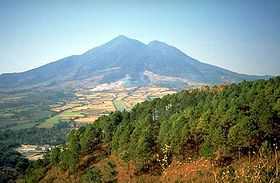 San Vicente in 1994 | |
| Elevation | 2,182 m (7,159 ft)[1] |
| Listing | Breast-shaped hills |
| Location | |
 San Vicente Location in El Salvador | |
| Location | El Salvador |
| Coordinates | 13°35′42″N 88°50′13″W / 13.595°N 88.837°WCoordinates: 13°35′42″N 88°50′13″W / 13.595°N 88.837°W[1] |
| Geology | |
| Type | Stratovolcano |
| Last eruption | Unknown[1] |
San Vicente (also known as Chichontepec or Las Chiches) is a stratovolcano in central El Salvador. It is located next to the town of San Vicente (hence the name) and is the second highest volcano in El Salvador. In the indigenous language Nahuat, Chichontepec means the mountain of the two breasts,[2] because its double summit resembles a woman's bosom. The volcano has two craters located one in each summit, although not exactly at the top. Dense vegetation covers both summits. Numerous hot springs and fumaroles are found on the northern and western flanks of the volcano. To the northeast, at 820 metres in a ravine of 180 metres of longitude, there are fumaroles -- fountains of clear and muddy water or small volcanoes of mud.
The last significant eruption occurred more than 1,700 years ago. The volcano may have had a very long history of repeated, and sometimes violent, eruptions, and at least once a large section of the volcano collapsed in a massive landslide.[3]
See also
References
- ↑ 1.0 1.1 1.2 "San Vicente". Global Volcanism Program. Smithsonian Institution. Retrieved 2010-04-16.
- ↑ "San Vicente". Michigan Technological University. Retrieved 2012-05-13.
- ↑ J.J. Major, S.P. Schilling, C.R. Pullinger, C.D. Escobar, and M.M. Howell. "Volcano-Hazard Zonation for San Vicente Volcano, El Salvador". USGS. Retrieved 2009-11-13.
| |||||||||||||||||||||||||||||