San Miguel Island
- For the Portuguese island, see São Miguel Island.


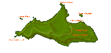
San Miguel Island is the westernmost of California's Channel Islands, located across the Santa Barbara Channel in the Pacific Ocean, within Santa Barbara County, California. San Miguel is the sixth-largest of the eight Channel Islands at 9,325 acres (37.74 km² or 14.57 sq mi), including offshore islands and rocks. Prince Island, 700 m (2,300 ft) off the northeastern coast, measures 35 acres (14 ha) in area. The island, at its farthest extent, is 8 miles (13 km) long and 3.7 miles (6.0 km) wide.
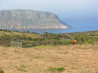
San Miguel Island is part of Channel Islands National Park, and almost all of the island (8,960 acres (36.3 km2)) has also been designated as an archaeological district on the National Register of Historic Places. This westernmost Channel Island receives northwesterly winds and severe weather from the open ocean. The cold and nutrient-rich water surrounding the island is home to a diverse array of sea life that is not found on the southern islands.
San Miguel Island, together with numerous small islets around it, is defined by the United States Census Bureau as Block 3010, Block Group 3, Census Tract 29.10 of Santa Barbara County, California. The island is uninhabited.[1] Highest peak is San Miguel Hill, at 831 feet (253 m). Submerged rocks make the nearly 28-mile (45 km) coastline a mariner's nightmare.
History
Archaeological research has shown that San Miguel Island was first settled by humans at least 12,000 years ago, in the Millingstone Horizon archaeological period. Because the northern Channel Islands have not been connected to the adjacent mainland in recent geological history, the Paleo-Indians who first settled the island clearly had boats and other maritime technologies. Rough seas and risky landings did not daunt the Chumash people. They called the island Tuquan in the Chumash language, and for several centuries, they used plank-built canoes, called tomols, to reach their settlements.
The first European explorer to land was the Portuguese explorer, João Rodrigues Cabrillo in 1542, who died on the island and is buried there. Ranchers raised sheep here from 1850 to 1948. One of the ranch families that homesteaded the longest was the Lesters, a family of four that left the island at the time of Pearl Harbor due to the dangers posed by the war.[2]
Later, the United States Navy used the island for a bombing range.
Park Service operations

The National Park Service maintains two airstrips, a ranger station and a research station on San Miguel Island. The Island is normally staffed by a ranger who enforces park laws, while also providing interpretive services for public visitors. The island also hosts scientists who study pinnipeds and manage the Island Fox captive breeding program that is conducted on the island. Volunteer interpretive rangers often fill in for regularly paid rangers due to budget deficits within the park.
Fauna
In July, 2011, researchers discovered that a "loomerie" (breeding colony) of the California Common Murre (Uria aalge californica) had returned to Prince Island, an islet off San Miguel Island, for the first time since 1912. Like penguins, the football-size black-and-white seabirds use their wings to "fly" deep underwater, but unlike penguins, they also fly in the air. This colony disappeared nearly a century ago, likely because of egg harvesting, but now their southern range is re-established.[3]
In the 1960s, Northern fur seals (Callorhinus ursinus) successfully recolonized San Miguel Island, making the island the 3rd American (and southernmost) breeding colony. The first seals had flipper tags identifying them as being from the Pribilof or Commander Islands in the Bering Sea. Today the San Miguel colony numbers around 10,000 animals.[4]
According to the Los Angeles Times, "Great white sharks haunt the waters around San Miguel Island, where they feast on seals and sea lions."[5] An urchin diver named James Robinson is believed to have been killed by a shark off Harris Point in the area known as Shark Park in 1994.[5]
Weather
San Miguel Island does not receive protection from the open ocean as the other Channel Islands. Most of the time a strong northwest wind blows across the island. These winds typically exceed 25 mph (40 km/h) and can surpass 50 mph (80 km/h). When strong high pressure is over the mainland, the winds often cease.
Heavy fog is common on the island, especially during May and June. On warmer days the fog will burn off only to have the strong northwest wind blow in additional fog from the open ocean. On foggy days the temperature will rarely exceed 55 °F (13 °C). Annual rainfall is about 17 inches, mostly falling between November and March.
Tourism
Normally fewer than 200 public visitors set foot on San Miguel Island during a given year. Currently the island is closed to tourism by the Navy to survey for unexploded ordnance leftover from the time that the island was used as a bombing site.
Visitors are transported to the island by boat. Island Packers is the only authorized concessionaire to the island, however private boaters are allowed to anchor off shore. Eight-foot seas are not uncommon in the Pacific between Santa Rosa Island and San Miguel Island.
Landing
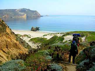
There is no pier on San Miguel Island, so all public visitors arrive on the island by skiff at Cuyler Harbor. Landing on the island can be an exciting experience, as the surf can swamp the landing boat. During ideal weather, visitors are put ashore directly in front of the trail that leads into the interior of the island. When the swell is high, visitors might be placed on the beach to the east or west, depending upon conditions.
Camping facilities
San Miguel Island includes a campground with ten sites. Each campsite includes a picnic table, wind break and an animal-proof box. The campground includes one pit toilet. Fires are prohibited due to the high winds and the inability to extinguish them. Sturdy tents are recommended as the wind can exceed 50 mph (80 km/h), even during the summer. It is recommended that campers tie their tents to the wind break to keep them from blowing away when not being occupied.
Hiking
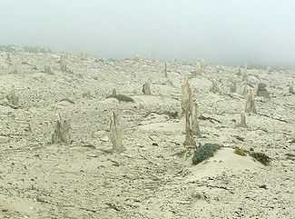
With the exception of the trail leading from the beach in Cuyler Harbor to the campground and ranger station, hiking is restricted to ranger-led outings. Many visitors participate in the 14-mile (23 km) round trip hike to Point Bennett to view the thousands of Elephant Seals and sea lions that reside at the west end of the island during spring and summer. Another popular hike is to the Island's caliche forest. Caliche is a type of hardened calcium deposit.
Water activities
Visitors to the island are restricted to ocean access at Cuyler Harbor. This landing is well protected from the strong ocean swell that is driven from the northwest. Cuyler has a sandy beach and visitors will often find themselves sharing the beach with elephant seals. The water is generally below 60 °F (16 °C), making it cold without a wetsuit. During low tides the harbor offers a tide pool area at the east end of the beach. Sea kayaking is not recommended for the novice as high winds can develop without notice. Bathers, divers and kayakers should be aware and alert to the occurrence of great white sharks in these waters. It is unwise to enter the water in early morning or late afternoon to early evening hours when sharks are feeding close to shore. An urchin diver was killed by a great white shark in 1994 off San Miguel Island.

Coordinates: 34°2′N 120°23′W / 34.033°N 120.383°W[6]
See also
References
- ↑ Block 3010, Block Group 3, Census Tract 29.10, Santa Barbara County United States Census Bureau
- ↑ Lester, Elizabeth Sherman (1974). The legendary king of San Miguel. Santa Barbara, Calif.: McNally & Loftin. ISBN 9780874610277. Retrieved 2013-04-26.
- ↑ "After Century's Absence, Seabirds' Return Surprises Scientists". ourAmazingplanet. 2011-12-27.
- ↑ Juliet Grable (2011-10-05). "Fur Seals Making a Comeback on the Farallones". Bay Nature. Retrieved 2012-12-19.
- ↑ 5.0 5.1 Shark Kills Skin Diver Off San Miguel Island, Los Angeles Times, 10 December 1994.
- ↑ U.S. Geological Survey Geographic Names Information System: San Miguel Island
Further reading
- Lester, Elizabeth Sherman (1974). The legendary king of San Miguel. Santa Barbara, Calif.: McNally & Loftin. ISBN 9780874610277. Retrieved 2013-04-26.
| Wikimedia Commons has media related to San Miguel Island. |
| ||||||||
| ||||||||||||||