San Miguel Department (El Salvador)
| San Miguel | ||
|---|---|---|
| Department | ||
 | ||
| ||
 Location within El Salvador | ||
| Coordinates: 13°31′19″N 88°14′02″W / 13.522°N 88.234°WCoordinates: 13°31′19″N 88°14′02″W / 13.522°N 88.234°W | ||
| Country |
| |
| Created (given current status) | 1824 | |
| Seat | San Miguel | |
| Area | ||
| • Total | 2,077.1 km2 (802.0 sq mi) | |
| Area rank | Ranked 2nd | |
| Population | ||
| • Total | 478,792 | |
| • Rank | Ranked 4th | |
| • Density | 230/km2 (600/sq mi) | |
| Time zone | CST (UTC−6) | |
| ISO 3166 code | SV-SM | |
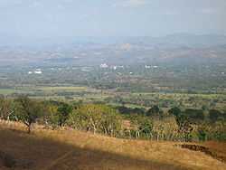
San Miguel is a department of El Salvador in the eastern part of the country. The capital is San Miguel. It has 2,077 km² and a population of over 478,000
San Miguel was first known as San Miguel de la Frontera. The city was founded by Luis de Moscoso on May 8, 1530, where it is now Santa Elena. This territory was part of the Lenca Principality at the time of the conquest. On July 11, 1812 it was given the title of "Noble y Leal Ciudad" (noble and loyal city). It was made a department on June 12, 1824.
Municipalities
- arolina
- Chapeltique
- Chinameca
- Chirilagua
- Ciudad Barrios
- Comacarán
- El Tránsito
- Lolotique
- Moncagua
- Nueva Guadalupe
- Nuevo Edén de San Juan
- Quelepa
- San Antonio
- San Gerardo
- San Jorge
- San Luis de la Reina
- San Miguel
- San Rafael
- Sesori
- Uluazapa
Agriculture
The products that are more cultivated are the basic grains, henequen and sugar cane, fruits, oleaginous seeds, mangrove, and grass. The upbringing of bovine, swinish, goat, and mule livestock exists and the upbringing of corral birds and of bees. Among the most important manufacturing, there is the elaboration of nutritious products, threads, yarns, drinks, cotton fabrics, clothes, leather articles, detergents, soaps, milk, and construction material.
Tourism
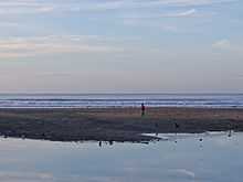
There are a few beaches in the San Miguel department, for instance in El Cuco.