San Marcos Department

San Marcos is a department in Guatemala. The capital is the city of San Marcos.
Departmental history
The department was created by a governmental decree on 8 May 1866, together with Huehuetenango, Izabal and Petén departments.[1] Before this it was known as the Barrio of San Marcos ("District of San Marcos"), which was a part of the department of Quetzaltenango.[1]
In 1902 the eruption of the Santa María volcano in the neighbouring department of Quetzaltenango was responsible for the destruction of the twin towns of San Marcos and San Pedro Sacatepéquez.[2] The towns were rebuilt and in 1935 were joined to form the new municipality of San Marcos La Unión.[2] This new municipality did not last long and the unified municipalities were again split in 1945 with San Marcos remaining the departmental capital.[2]
Geography
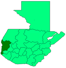
San Marcos is bordered on the north by the department of Huehuetenango, on the east by the department of Quetzaltenango, to the south by the department of Retalhuleu and by the Pacific Ocean, and on the west by the Mexican state of Chiapas.[3] The department has a total territory of 2,397 square kilometres (925 sq mi).[4]
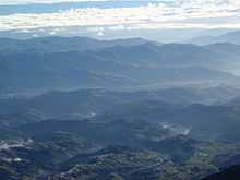
The northern portion of the department is mountainous, being crossed by the Sierra Madre mountain range, with the two highest volcanoes in Central America being located within its borders.[3] These are Tajumulco (4,220 metres (13,850 ft) high) and Tacaná (4,092 metres (13,425 ft) high).[3][5] The Tajumulco volcano is the highest peak in Central America.[6] Other notable peaks include San Antonio Ichiguán at 4,022 metres (13,196 ft) above mean sea level.[3] The southern portion of the department drops away towards the Pacific coast.[7]
The Tacaná volcano, which occupies the border with Mexico and has slopes in both countries, has been historically active, with activity recorded in 1855, 1878, from 1900 through to 1903, from 1949 to 1950 and from 1986 to 1987.[5]
Principal rivers in the department include the Suchiate River, which marks the border between San Marcos and Mexico and flows into the Pacific.[7] The Cabuz River has its source on the slopes of the Tajumulco volcano.[7] Other rivers include the El Pajapa, El Rodeo, Ixlamá, Ixtal, Meléndrez, Nahuatán, Ocosito and Tilapa Rivers.[7]
The climate varies widely within the department, due to the dramatic differences in altitude, with the north possessing a cold highland climate and the south having a temperate or hot climate, depending on the specific altitude.[7]
Population
The 2002 census recorded the total population of San Marcos department as 794,951.[8] Languages spoken in the department include Spanish, Mam and Sipakapense.[9]
Economy and agriculture
The wide variety of climates within the department resulting from differences in altitude gives rise to a variety of agricultural products.[7] Agricultural products include apples, bananas, barley, beans, cacao, coffee, maize, oats, peaches, plantains, potatoes, rice, sugarcane and wheat.[10] Livestock include cattle, horses and sheep.[7] San Marcos department produces more wool than any other department of Guatemala.[7] It is generally exported to the departments of Quetzaltenango and Totonicapán, where it is processed into finished products.[7] The department produces wooden furniture, with production being concentrated in the Pacific lowlands due to the greater variety of wood available, including cedar, ceiba and tepemixte.[7]
The department is notable for the importation of black market Mexican products, which are sold openly in local markets throughout its territory and from there are exported throughout Guatemala.[11]
Municipalities
The department of San Marcos is divided into 30 municipalities:[9]
| Municipality[8] | Ethnicity | Population[8][nb 1] | Festival[12] | Altitude[11] | Extent[11] |
|---|---|---|---|---|---|
| Ayutla | 27,435 | 1st Friday of Lent | 24 metres (79 ft) | 204 square kilometres (79 sq mi) | |
| Catarina | 24,561 | 25 November | 233 metres (764 ft) | 76 square kilometres (29 sq mi) | |
| Comitancillo | 46,371 | 3 May | 2,280 metres (7,480 ft) | 113 square kilometres (44 sq mi) | |
| Concepción Tutuapa | 49,363 | 8 December | 2,910 metres (9,550 ft) | 176 square kilometres (68 sq mi) | |
| El Quetzal | 18,979 | 12 November & 6 January | 940 metres (3,080 ft) | 88 square kilometres (34 sq mi) | |
| El Rodeo | 14,125 | 19 March | 700 metres (2,300 ft) | 81 square kilometres (31 sq mi) | |
| El Tumbador | 35,501 | 6 January | 920 metres (3,020 ft) | 84 square kilometres (32 sq mi) | |
| Esquipulas Palo Gordo | 8,613 | 15 January | 2,474 metres (8,117 ft) | 21 square kilometres (8.1 sq mi) | |
| Ixchiguan | 20,324 | 5th Friday of Lent, 23 January & 29 July | 3,200 metres (10,500 ft) | 183 square kilometres (71 sq mi) | |
| La Reforma | 14,623 | 1 January | 1,139 metres (3,737 ft) | 100 square kilometres (39 sq mi) | |
| Malacatán | 70,834 | 13 December | 390 metres (1,280 ft) | 204 square kilometres (79 sq mi) | |
| Nuevo Progreso | 26,140 | 12 December | 660 metres (2,170 ft) | 140 square kilometres (54 sq mi) | |
| Ocós | 29,257 | 3 metres (9.8 ft) | 205 square kilometres (79 sq mi) | ||
| Pajapita | 16,600 | 8 December | 97 metres (318 ft) | 84 square kilometres (32 sq mi) | |
| Río Blanco | Mam[13] | 4,872 | 8 July[13] | 2,650 metres (8,690 ft) | 21 square kilometres (8.1 sq mi) |
| San Antonio Sacatepéquez | 14,658 | 17 January | 2,338 metres (7,671 ft) | 79 square kilometres (31 sq mi) | |
| San Cristóbal Cucho | 13,928 | 29 July | 2,350 metres (7,710 ft) | 36 square kilometres (14 sq mi) | |
| San José Ojetenam | 16,541 | 19 March | 3,050 metres (10,010 ft) | 37 square kilometres (14 sq mi) | |
| San Lorenzo | 9,714 | 10 August | 1,620 metres (5,310 ft) | 25 square kilometres (9.7 sq mi) | |
| San Marcos | 36,325 | 25 April | 2,397 metres (7,864 ft) | 121 square kilometres (47 sq mi) | |
| San Miguel Ixtahuacán | 29,658 | 29 September | 2,050 metres (6,730 ft) | 184 square kilometres (71 sq mi) | |
| San Pablo | 36,535 | 25 January | 610 metres (2,000 ft) | 124 square kilometres (48 sq mi) | |
| San Pedro Sacatepéquez | 58,005 | 29 June | 2,330 metres (7,640 ft) | 253 square kilometres (98 sq mi) | |
| San Rafael Pie de La Cuesta | 13,072 | 24 October | 1,038 metres (3,406 ft) | 60 square kilometres (23 sq mi) | |
| Sibinal | 13,268 | 29 September | 2,510 metres (8,230 ft) | 176 square kilometres (68 sq mi) | |
| Sipacapa | 14,043 | 24 August | 1,970 metres (6,460 ft) | 152 square kilometres (59 sq mi) | |
| Tacaná | 62,620 | 15 August | 2,410 metres (7,910 ft) | 302 square kilometres (117 sq mi) | |
| Tajumulco | 41,308 | 8 July | 2,050 metres (6,730 ft) | 300 square kilometres (120 sq mi) | |
| Tejutla | 27,672 | 25 July | 2,520 metres (8,270 ft) | 142 square kilometres (55 sq mi) | |
| La Blanca[14] |
Tourism

The main tourist attractions of the San Marcos department are its various Pacific beaches.[4] Other attractions include thermal baths and the caves of Castalia.[4]
Notes
- ↑ 2002 census.
Citations
- ↑ 1.0 1.1 del Aguila 2005, p.2.
- ↑ 2.0 2.1 2.2 Hernández & Martínez 2004.
- ↑ 3.0 3.1 3.2 3.3 del Aguila 2005, p.13.
- ↑ 4.0 4.1 4.2 Servicio de Información Municipal de Inforpress (1).
- ↑ 5.0 5.1 INSIVUMEH
- ↑ Encyclopædia Britannica Online 2011.
- ↑ 7.0 7.1 7.2 7.3 7.4 7.5 7.6 7.7 7.8 7.9 del Aguila 2005, p.14.
- ↑ 8.0 8.1 8.2 del Aguila 2005, p.9.
- ↑ 9.0 9.1 del Aguila 2005, p.15.
- ↑ del Aguila 2005, p.14. Hernández & Martínez 2004.
- ↑ 11.0 11.1 11.2 del Aguila 2005, p.16.
- ↑ del Aguila 2005, p.17.
- ↑ 13.0 13.1 Servicio de Información Municipal de Inforpress (2).
- ↑ Crean nuevo municipio en San Marcos. Agencia Guatemalteca de Noticias, 24 January 2014.
References
- del Aguila Bernasconi, Juan Enrique (2005). San Marcos: Información Histórica - Geográfica del Departamento (in Spanish). Guatemala: Del Aguila Consultores.
- Encyclopædia Britannica Online (2011). "Tajumulco Volcano.". Encyclopædia Britannica. Encyclopædia Britannica Online. Retrieved 2011-01-14.
- Hernández, Gonzalo; Martínez, Mildred (2004). "San Marcos: La capital de la hospitalidad" (PDF) (in Spanish). Guatemala: Prensa Libre. Retrieved 2011-01-14.
- INSIVUMEH. "Volcanes de Guatemala" (in Spanish). Guatemala City: Instituto Nacional de Sismología, Vulcanología, Meteorologíá e Hidrologíá (INSIVUMEH) - Ministerio de Comunicaciones, Infraestructura y Vivienda. Retrieved 2011-01-14.
- Servicio de Información Municipal de Inforpress (1). "Departamento de San Marcos" (in Spanish). Guatemala City: INFORPRESSCA. Retrieved 2010-01-12.
- Servicio de Información Municipal de Inforpress (2). "Río Blanco, San Marcos" (in Spanish). Guatemala City: INFORPRESSCA. Retrieved 2010-01-12.
Coordinates: 14°57′40″N 91°47′44″W / 14.96111°N 91.79556°W