San Ignacio, Belize
Coordinates: 17°9′36.45″N 89°3′35.99″W / 17.1601250°N 89.0599972°W
| San Ignacio-Santa Elena | |
|---|---|
| Town | |
| Twin Towns of San Ignacio and Santa Elena | |
|
San Ignacio Town | |
| Nickname(s): Cayo, Cayo Town, Twin Towns | |
| Motto: The Best Come From The West | |
 San Ignacio-Santa Elena | |
| Coordinates: 17°9′36.45″N 89°3′35.99″W / 17.1601250°N 89.0599972°W | |
| Country |
|
| District | Cayo |
| Constituency | Cayo Central, Cayo North, Cayo North East |
| Founded | 1800s |
| Government | |
| • Mayor | Earl Trapp |
| • Area Representatives |
Omar Figueroa (UDP) Rene Montero (UDP) Elvin Penner (UDP) |
| Area | |
| • Total | 6 km2 (2.5 sq mi) |
| Elevation | 76 m (249 ft) |
| Population (2010)[1] | |
| • Total | 16,977 |
| Time zone | Central (UTC-6) |
| Website | Official website |

San Ignacio and Santa Elena are towns in western Belize. San Ignacio serves as the cultural-economic hub of Cayo District. It got its start from Mahogany and chicle production during British colonialism. Over time, it attracted different people from the surrounding areas, which led to the diverse population of the town at present day.
History
The town was originally named El Cayo by the Spanish. On October 19, 1904, El Cayo was officially declared a town by the government of British Honduras. In the past a creek ran between the macal and the mopan rivers one mile outside of San Ignacio going toward Benque Viejo. This creek then fulfilled the definition of an area of land completely surrounded by water and thus the name Cayo. There was a big wooden bridge across this creek in the late nineteen forties, but since the creek eventually dried up the area was filled with lime stone gravel and today there remains no evidence of its past existence. This unfortunate demise of the creek, however, took away the distinction of the classification 'cayo' from the venerable western town of 'El Cayo' and returned it to a regular land mass no longer an island.
Geography
San Ignacio is situated on the banks of the Macal and Mopan Rivers, about 63 miles (101 km) west of Belize City and 22 miles (35 km) west of the country's capital, Belmopan. The town has a total area of approximately 2.5 square miles (6.5 km2).[2]
-

View of San Ignacio, looking towards the Hawksworth Bridge
-
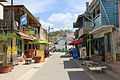
Burns Avenue
-

Small park of downtown San Ignacio in front of the police station
-
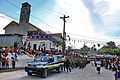
Belize independence day celebration
Demographics
The population is largely Mestizo and Kriol, with some Lebanese and Mopan. San Ignacio also boasts a fairly large Chinese population, most of whom emigrated from Guangzhou in waves in the mid-20th century. A sizable Mennonite community resides near San Ignacio. In 2009 the combined population was estimated at 20,000 people but a new census in 2010 counted only 9,925 inhabitants in San Ignacio proper, of whom 4,856 are males and 5,069 are females. The total number of households is 2,593 and the average household size is 3.8.[1]
Santa Elena
In recent years San Ignacio has absorbed the formerly separate village of Santa Elena. San Ignacio and its sister-town Santa Elena make up Belize's second largest urban area. The two towns are connected by Belize's only suspension bridge, the one-lane Hawksworth Bridge across the Macal river, built in 1949.[3] The two are collectively referred to as the "Twin Towns" although San Ignacio has a larger population.
Government
San Ignacio is currently governed by a Town Council affiliated with the United Democratic Party (UDP). The mayor is John August Jr. Town council elections are made every three years to elect a new town mayor, both, UDP (United Democratic Party) and the PUP (People's United Party) candidates participate in town elections.
Educational institutions
San Ignacio has three main colleges. Sacred Heart College of Catholic denomination is the biggest and largest institution with both a high school and a junior college division. Eden Seventh Day Adventist High School and Saint Ignatius High School (Catholic) is also found here. Galen University was founded in 2003 and is located at Central Farm, a couple of minutes away from San Ignacio. The University of Belize also has an agricultural campus next to Galen.
Medicine
The city is served by the San Ignacio Hospital and the Loma Luz Adventist hospital in Santa Elena. It also has various clinics, doctors and pharmacies scattered around town.
Attractions
The area around San Ignacio is one of the most popular parts of the country for tourism. Nearby attractions include the ancient Maya ruins of Caracol, Xunantunich, Cahal Pech, El Pilar, Tikal (Guatemala), the cave Actun Tunichil Muknal, San Ignacio Resort Hotel Iguana Conservation Project Chaa Creek Nature Reserve, and the Mountain Pine Ridge Forest Reserve.
Visitors can tour the Mayan ruins independently by foot or by car, or by participating in the many local tour companies that include guided tours of the ruins.
See also
References
- ↑ 1.0 1.1 "Census 2010 Provisional Population and Households, by Sex and Major Geographic Divisions" (PDF). Statistical Institute of Belize. Retrieved 19 May 2011.
- ↑ "Chapter 87: Town Councils Act, Revised Edition 2003" (PDF). The Laws of Belize. Government of Belize. Retrieved 23 November 2013.
- ↑ "San Ignacio Town". duPlooy Travel. Retrieved 19 May 2011.
External links
| Wikimedia Commons has media related to San Ignacio, Belize. |
| Wikivoyage has a travel guide for San Ignacio. |
- Maps of San Ignacio, Belize
- San Ignacio Travel information - Belize Travel Magazine