San Andrés Itzapa
| San Andrés Itzapa | |
|---|---|
| Municipality and town | |
 San Andrés Itzapa | |
| Coordinates: 14°37′N 90°51′W / 14.617°N 90.850°W | |
| Country |
|
| Department |
|
| Area | |
| • Total | 30 sq mi (90 km2) |
| Time zone | Central Time (UTC+6) |
| Climate | Cwb |
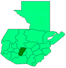
San Andrés Itzapa (Spanish pronunciation: [anˈdɾes itˈsapa]) is a municipality of Chimaltenango, Guatemala. San Andrés Itzapa is in the eastern region of Chimaltenango, while the district capital lies to the north, Acatenango lies to the south and to the east is Parramos. The city occupies an area of 90 square kilometres, with a total of 31,956 inhabitants, who are called Itzapecos.
Origin of the name
San Andres Itzapa (Itzapa means flint) is an ancient town. The village is mentioned in the Annals of the Cakchiquels, written in 1571. The Spanish named the area "Itzapa y de San Andrés" in honor of their patron saint, the apostle San Andrés (Saint Andrew). The Spanish also called the area "Valle del Durazno" (Valley of the peaches), as the prickly pears common in this area resembled the orchards of home.
Organisation
The city consists of 9 villages: Chicazanga, Chimachoy, Panimaquin, San José Calderas, Yerba Buena, El Aguacate, San José Los Corrales, Xiparquiy, and San José Cajahualten.
Languages
Both Spanish and Kaqchiquel are spoken, although migration from other regions has brought an influx of other languages, such as K'iché and Tz'utujil.
Flora and fauna
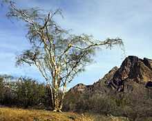
San Andrés Itzapa has several heavily forested areas, which include eucalyptus, poplars, pines, holly, oaks, cypress and other evergreen and deciduous species.
Plants found in San Andrés Itzapa include canaque, casuarina, conacaste, hormigo, grabilea and palo blanco, as well as varieties of aloe.
Animals include coyote, armadillos, mountain lions, tisote, lynxes, goyoy, kinkajou, squirrels, racoons, wild boars, dove, cayayes, pajuil, and pheasant.
Agricultural products
Wheat, cotton, corn, beans, avocado, chayote, beet, radish, squash, carrot, broccoli, cabbage, coffee and guaque Chile peppers are grown.
Crafts
The municipality is rich in the craftsmanship of leather goods such as knife and machete sheaths, sandals, articles of jade, tables and chairs, ropemaking, and others.
Celebrations
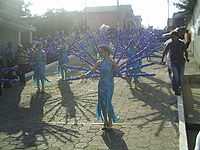
- Convite (the last Saturday of January)
- Feria Titular (from 22 November to 1 December)
- Corpus Christi (late June)
- Corrida de Cintas (15th of September)
- Maximón (28th of October)
- Saint Andrew the Apostle (30th of November)
Places of interest
- Xipacay bath
- Temple of San Simón
Volunteer Organizations
- Maya Pedal - small local NGO dedicated to supporting rural development through the design and production of pedal powered machines, or bicimaquinas. As of September 2012, Maya Pedal recently underwent an organizational change, please refer to the website or Facebook page for more information. [1]
- Project Genesis- Local nonprofit that provides education and community development programs to the children of San Andrés and the surrounding villages. It aims to build a school and begin employing full-time teachers. The project currently relies on international volunteers, and was founded by Ricardo Armas who lives in Jocotenango.
References
Coordinates: 14°37′N 90°51′W / 14.617°N 90.850°W
| |||||||||||||