San Agustín Lanquín
| San Agustín Lanquín | |
|---|---|
| Municipality | |
|
Catholic Church of Lanquín | |
 San Agustín Lanquín Location in Guatemala | |
| Coordinates: 15°34′33″N 89°58′52″W / 15.57583°N 89.98111°W | |
| Country |
|
| Department |
|
| Municipality | Lanquín |
| Founded | 1540 |
| Government | |
| • Type | Municipal |
| • Mayor | Francisco Pop (UNE) |
| Area | |
| • Total | 208 km2 (80 sq mi) |
| Elevation | 380 m (1,250 ft) |
| Population (Census 2002)[1] | |
| • Total | 16,546 |
| • Ethnicities | Q'eqchi' (95%), Ladino (5%) |
| • Religions | Roman Catholicism, Evangelicalism, Maya |
| Climate | Af |
| Website | www.inforpressca.com/lanquin |
San Agustín Lanquín (Spanish pronunciation: [san aɣusˈtin laŋˈkin]), often referred to simply as Lanquín, is a municipality in the Guatemalan department of Alta Verapaz. It is situated at 380 m above sea level. It contains 16,500 people, many of Q'eqchi' Maya descent. It covers an area of 208 km².
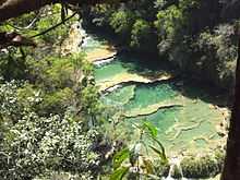
A large cave complex, known as Grutas de Lanquín is situated just 1 km west of the town, and 11 km south of Lanquín is the Cahabón River and its natural monument Semuc Champey. Lanquín is often used as starting point for trips to Semuc Champey.
 Cahabón River near Lanquin |
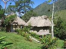
 Landscape with cabin in Lanquin |
References
External links
 Media related to Lanquin at Wikimedia Commons
- semucchampey.com
- Muni in Spanish
| |||||||||||||
Coordinates: 15°34′N 89°58′W / 15.567°N 89.967°W