Salto, São Paulo
Coordinates: 23°12′03″S 47°17′13″W / 23.20083°S 47.28694°W
| Salto Município da Estância Turística de Salto | |||
|---|---|---|---|
| Municipality | |||
|
View Tietê River, through the dam of Salto | |||
| |||
|
Nickname(s): "Cidade dos Taperás" "City of Taperas" | |||
 | |||
| Country |
| ||
| Federal Unit | São Paulo | ||
| Mesoregion | Macro Paulista Metropolitan | ||
| Microregion | Sorocaba | ||
| Government | |||
| • Mayor | Juvenil Cirelli (Workers' Party) | ||
| Area | |||
| • Total | 134.258 km2 (51.837 sq mi) | ||
| Elevation | 555 m (1,821 ft) | ||
| Population (2010)[1] | |||
| • Total | 105 569 | ||
| Time zone | UTC-3 (UTC-3) | ||
| • Summer (DST) | UTC-2 (UTC-2) | ||
| Website |
www | ||
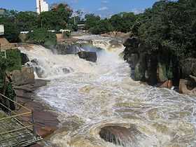


Salto is a municipality in the state of São Paulo in Brazil. The elevation is 555 m. The city has one main river, rio Tietê. Poll from 2004 shows the population is 103.884.
The city has an important geological park: "Moutonée Park".
References
- ↑ "Censo Populacional 2010" [Population Census 2010]. Censo Populacional 2010 (in Portuguese). Instituto Brasileiro de Geografia e Estatística (IBGE). Retrieved 14 September 2013.