Salt Pans, Portland

The Salt Pans are two salt pans on the Isle of Portland, Dorset, England. Both pans sit next to one another, and are situated on the coastline of East Weares, the east side of Portland. The pans sit directly below the Young Offenders Institution HM Prison Portland, and are found close to various old historic relics such as the East Weares Rifle Range, Folly Pier, King's Pier and the remains of the Folly Pier Waterworks. The East Weares area, including the Salt Pans, has been labelled a Site of Special Scientific Interest (SSSI), largely due to the scrub and wildlife being of high nature conservation value.[1]
History

Situated in a discreet section of the island's eastern coastline, the two pan-shaped salt pans are have existed for many centuries. During Saxon and Norman times the production of salt was a major industry for the island. As such there were two sites for the production of salt - the two salts pans on the eastern coastline, and at the tidal lagoon known as The Mere, which used to exist on the northern side of the island.[2]
The origins of the pans remain uncertain, and suggestions have been made that the Romans created them. However the limited evidence recorded suggest they are more likely to be medieval.[3] They were formed by being dug out of the exposed Kimmeridge clay. The pans would flood at high Spring Tides and once they dried out through the evaporation of the seawater, local people would scrape the encrustation of salt off the rocks.[2] [3]
Although the pans have remained unused for centuries, both remain completely intact and undisturbed. This can be partly attributed to the fact that the majority of the East Weares area has remained uninhabited and any historic sites that remain are derelict and fully abandoned too. The salt pool of The Mere was destroyed long ago, and the Mere itself was later reclaimed and once the Portland Branch Railway was created, the lagoon was completely infilled, and today is the coastguard helicopter base.[4]
In one of the pans, the outing casing of an old empty naval mine has laid rusting for decades and still remains visible to date. The surrounding grassland area around the pans has remained a favourite and popular site for locals to spell out messages in rocks as they can be seen directly from the roadway high above around the side of the Young Offenders Institution. Additionally, a little further past the pans heading south is a Victorian sewer ventilator, which is now disued. The small pebbled coastline Little Beach further south openly reveals soft Kimmeridge Clay stratum at sea level. Next to the right-hand salt pan is also an old stone jetty which remains intact to date.[3]
Access
The salt pans can be reached via an unofficial pathway veering off the official coastal path of the East Weares area. A similar pathway further north links to the remains of the Folly Pier Waterworks. Sitting on the coastline, the pans link directly to the sea and thus can be reached via the coastline edge as well. The pans can also be viewed from the clifftops of Grove Point.
References
- ↑ "File:East Weares - Portland Goats Sign - Portland, Dorset.JPG - Wikimedia Commons". Commons.wikimedia.org. Retrieved 2013-12-03.
- ↑ 2.0 2.1 Morris, Stuart (1985). Portland, an Illustrated History. Dorset: The Dovecote Press, Wimborne, Dorset. p. 20. ISBN 0-946159-34-3.
- ↑ 3.0 3.1 3.2 "Salt pans, a mine and a dead whale on Portland, Dorset". Geoffkirby.co.uk. Retrieved 2013-12-03.
- ↑ "Chesil Beach, Dorset - Geological Field Guide, Introduction by Dr. Ian West". Southampton.ac.uk. Retrieved 2013-12-03.
-

The high nature conservation scrub surrounding the salt pans.
-

The southern-most salt pan seen up close.
-
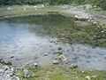
The north-most salt pan seen up close.
-
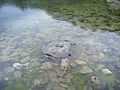
The old naval mine found in the north-most pan.
-

The north-most pan again, positioned on the coastline.
-

The stone jetty seen close to both pans, further south.
-

Both pans seen from the cliff top again, with the coastal path running further above the pans.
Coordinates: 50°33′03″N 2°24′59″W / 50.5508°N 2.4165°W
| ||||||||||||||||||||||||||||||||||||||||||||||||||||||||||||||||||