Salses-le-Château
| Sales-le-Château | |
|---|---|
|
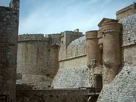
Entrance of the Fort de Salses | |
 Sales-le-Château | |
|
Location within Languedoc-Roussillon region  Sales-le-Château | |
| Coordinates: 42°50′01″N 2°55′11″E / 42.8336°N 2.9197°ECoordinates: 42°50′01″N 2°55′11″E / 42.8336°N 2.9197°E | |
| Country | France |
| Region | Languedoc-Roussillon |
| Department | Pyrénées-Orientales |
| Arrondissement | Perpignan |
| Canton | Rivesaltes |
| Intercommunality | Rivesaltais–Agly–Manadeil |
| Government | |
| • Mayor (2001–2008) | Marie-Claude Grégoire |
| Area1 | 71.28 km2 (27.52 sq mi) |
| Population (2006)2 | 2,894 |
| • Density | 41/km2 (110/sq mi) |
| INSEE/Postal code | 66190 / 66600 |
| Elevation |
0–354 m (0–1,161 ft) (avg. 12 m or 39 ft) |
|
1 French Land Register data, which excludes lakes, ponds, glaciers > 1 km² (0.386 sq mi or 247 acres) and river estuaries. 2 Population without double counting: residents of multiple communes (e.g., students and military personnel) only counted once. | |
Salses-le-Château or just Salses is a commune in the Pyrénées-Orientales department in southern France.
It is located north of the city of Perpignan.
Geography
Salses-le-Château is located in the canton of Rivesaltes and in the arrondissement of Perpignan.

Map of Salses-le-Château and its surrounding communes
Sites of interest
- Fort de Salses
- The Gate of the Catalan Countries is located in Salses.
See also
References
| Wikimedia Commons has media related to Salses-le-Château. |