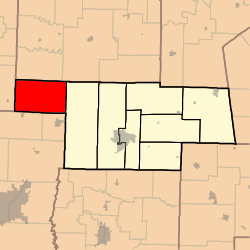
Saling Township, Audrain County, Missouri
| Saling Township | |
|---|---|
| Township | |
 | |
| Coordinates: 39°17′03″N 092°10′11″W / 39.28417°N 92.16972°WCoordinates: 39°17′03″N 092°10′11″W / 39.28417°N 92.16972°W | |
| Country | United States |
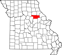
| State | Missouri |
| County | Audrain |
| Area | |
| • Total | 78.58 sq mi (203.51 km2) |
| • Land | 78.35 sq mi (202.92 km2) |
| • Water | 0.23 sq mi (0.59 km2) 0.29% |
| Elevation[1] | 843 ft (257 m) |
| Population (2010) | |
| • Total | 1,472 |
| • Density | 19/sq mi (7.3/km2) |
| FIPS code | 29-65432[2] |
| GNIS feature ID | 0766245 |
Saling Township is one of eight townships in Audrain County, Missouri, United States. As of the 2010 census, its population was 1,472.[3]
History
Saling was the name of a settler.[4]
Geography
Saling Township covers an area of 78.6 square miles (203.5 km2) and contains no incorporated settlements. It contains one cemetery, Mount Pisgah.
Larrabee Lake is within this township. The streams of Big Creek and Boat Branch run through this township.
References
- ↑ "US Board on Geographic Names". United States Geological Survey. 2007-10-25. Retrieved 2008-01-31.
- ↑ "American FactFinder". United States Census Bureau. Retrieved 2008-01-31.
- ↑ "Geographic Identifiers: 2010 Demographic Profile Data (G001): Saling township, Audrain County, Missouri". U.S. Census Bureau, American Factfinder. Retrieved June 25, 2013.
- ↑ Eaton, David Wolfe (1916). How Missouri Counties, Towns and Streams Were Named. The State Historical Society of Missouri. p. 204.
External links
| |||||||||||||||||||||||||||||