Saline River (Little River)
| Saline River | |
|---|---|
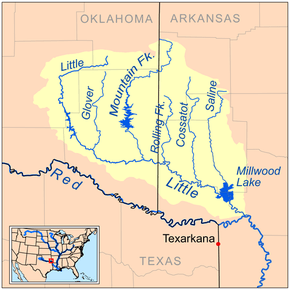 Map of the Little River watershed showing the Saline River | |
| Origin | Ouachita Mountains 34°23′01″N 93°59′48″W / 34.38372°N 93.99659°W[1] |
| Mouth | Millwood Lake, Little River 33°43′54″N 93°58′06″W / 33.73179°N 93.96824°W[1] |
| Basin countries | United States |
| Length | 80 miles (130 km) |
| Source elevation | 259 feet (79 m) |
The Saline River is an 80-mile-long (130 km)[2] tributary of the Little River in southwestern Arkansas in the United States. Via the Little and Red rivers, it is part of the watershed of the Mississippi River.
It rises in the Ouachita Mountains in southeastern Polk County, in the Ouachita National Forest, and flows generally south through Howard County and along Howard County's boundary with Sevier County, through Dierks Lake, which is formed by a U.S. Army Corps of Engineers dam. It enters the Little River as part of Millwood Lake, which is formed by another USACE dam on the Little River.
See also
- List of Arkansas rivers
References
- ↑ 1.0 1.1 "Saline River". Geographic Names Information System. United States Geological Survey. Retrieved 2014-01-13.
- ↑ "The National Map". U.S. Geological Survey. Retrieved March 8, 2011.
External links
References
- DeLorme (2004). Arkansas Atlas & Gazetteer. Yarmouth, Maine: DeLorme. ISBN 978-0-89933-345-8.
- The Encyclopedia of Arkansas History & Culture