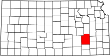
Salem Township, Greenwood County, Kansas
| Salem Township | |
|---|---|
| Township | |
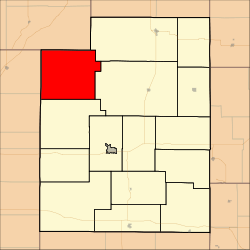 Location in Greenwood County | |
| Coordinates: 38°01′15″N 096°26′01″W / 38.02083°N 96.43361°WCoordinates: 38°01′15″N 096°26′01″W / 38.02083°N 96.43361°W | |
| Country | United States |
| State | Kansas |
| County | Greenwood |
| Area | |
| • Total | 90.72 sq mi (234.96 km2) |
| • Land | 89.91 sq mi (232.87 km2) |
| • Water | 0.81 sq mi (2.1 km2) 0.89% |
| Elevation | 1,565 ft (477 m) |
| Population (2000) | |
| • Total | 35 |
| • Density | 0.4/sq mi (0.2/km2) |
| GNIS feature ID | 0474421 |
Salem Township is a township in Greenwood County, Kansas, USA. As of the 2000 census, its population was 35.
Geography
Salem Township covers an area of 90.72 square miles (235.0 km2) and contains no incorporated settlements. The ghost town of Teterville is located in the township.
The streams of Battle Creek and Swing Creek run through this township.
References
External links
| |||||||||||||||||||||||||