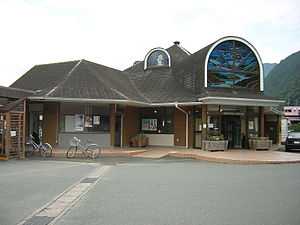
Sakuma Station
Sakuma Station 佐久間駅 | |
 | |
|---|---|
| Sakuma Station | |
| Location | |
| Prefecture | Shizuoka (See other stations in Shizuoka) |
| City | Hamamatsu |
| Ward | Tenryū |
| Neighborhood etc. | Sakuma-cho, Sakuma 2434 |
| Postal code | 431-3901 |
| (in Japanese) | 浜松市天竜区佐久間町佐久間2434 |
| History | |
| Year opened | 1936 |
| Former name | Sakuma-Misakuboguchi Station |
| Present name since | 1938 |
| Rail services | |
| Operator(s) | Central Japan Railway Company |
| Line(s) | Iida Line |
Sakuma Station (佐久間駅 Sakuma-eki) is a railway station on the Iida Line in Tenryū-ku, Hamamatsu, Shizuoka Prefecture, Japan. It is located 63.5 rail kilometers from the southern terminus of the Iida Line at Toyohashi Station.
Station history
Sakuma station was established on November 10, 1936 as the "Sakuma-Masakuboguchi stop" (佐久間水窪口停留場) on the now-defunct Sanshin Railway. Its name was changed to the "Sakuma stop" in 1938, and it was upgraded to a full station on February 7, 1941. On August 1, 1943, the Sanshin Railway was nationalized along with several other local lines to form the Iida line.
The station was relocated slightly to the west in 1955 as a part of rerouting of the line to avoid the rising waters of the Sakuma Dam. All freight services were discontinued in December 1971 and the station were unmanned from February 1984. Along with its division and privatization of JNR on April 1, 1987, the station came under the control and operation of the Central Japan Railway Company. The station is unmanned.
Lines
Layout
Sakuma station is a manned station with a single elevated side platform. The station building doubles as a branch of the Hamammatsu City Library, and passengers waiting for trains have access to the collection. The station formerly had an island platform, but was rebuilt in 2008.
Adjacent stations
| « | Service | » | ||
|---|---|---|---|---|
| Iida Line | ||||
| Limited Express "Inaji" (特急「伊那路」): no stop | ||||
| Chūbu-Tenryū | Local (普通) | Aizuki | ||
External links
- (Japanese) Iida Line station information
| Wikimedia Commons has media related to Sakuma Station. |
Coordinates: 35°05′32″N 137°48′37″E / 35.092127°N 137.810158°E