Sakleshpur
| ಸಕಲೇಶಪುರ Sakalaishwaryapura मंज़राबाद | |
|---|---|
| hill station | |
|
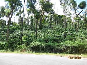
Coffee Plantation near Sakleshpur | |
 ಸಕಲೇಶಪುರ Location in Karnataka, India | |
| Coordinates: 12°58′N 75°47′E / 12.97°N 75.78°ECoordinates: 12°58′N 75°47′E / 12.97°N 75.78°E | |
| Country |
|
| State | Karnataka |
| District | Hassan |
| Elevation | 949 m (3,114 ft) |
| Population (2001) | |
| • Total | 23,201 |
| Languages | |
| • Official | Kannada |
| Time zone | IST (UTC+5:30) |
| PIN | 573134 |
| Telephone code | +91–8173 |
| Vehicle registration | KA-46 |
| Sex ratio | 100:80 ♂/♀ |
| Website | www.sakaleshpuratown.gov.in |
Sakleshpur (kannada: ಸಕಲೇಶಪುರ) is a hill station town and headquarters of Sakleshpur Taluk in Hassan district in the Indian state of Karnataka. It is referred to as 'poor man's Ooty'[1]
The town lies in the Malnad region on the magnificent hills of the biodiversity hotspot, the Western Ghats. It has a temperate climate surrounded with lofty green hills full of coffee, cardamom, pepper and areca plantations . These crops which contribute mainly to the economy of the Taluk are grown in the surrounding villages and entire taluk are brought to Sakleshpur city for sale. The town lies on National Highway 48 (NH-48) which connects port city of Mangaluru with capital city Bengaluru of Karnataka state. The nearest airport is Mangalore International Airport.
Geography
Sakleshpur is located at 12°58′N 75°47′E / 12.97°N 75.78°E.[2] It has an average elevation of 949 metres (3113 feet). Hemavathi river flows in Sakleshpur town
Climate
Sakleshpur receives very heavy rainfall from the southwest monsoon. It is one of the place receiving the most rainfall in Karnataka. The places are like Agani (near Hanbal-here the average rainfall is believed to be more than that of Agumbe, which receives the highest rainfall in South India, it's still considered as a speculation because of absence of an official rain-gauge) kagineri, bajemane, bisile, yedekumeri and even Maragunda. The analysis of last 16 (1996–2011) years data reveals that the highest (Av.2050.3 mm) rainfall has occurred in Sakleshpur. In 1997 it has received 2916 mm rainfall In 2010 it has received 2920 mm.
Demographics
As of 2001 India census,[3] Sakleshpur had a population of 23,201. Males constitute 51% of the population and females 49%. Sakleshpur has an average literacy rate of 74%, higher than the national average of 59.5%: male literacy is 78%, and female literacy is 69%. In Sakleshpur, 12% of the population is under 6 years of age.
History
The name Shakala is a Sanskrit word means "Bhinnavada" or "Birukada". In the past a Shivalinga found in this town which was broken. The linga was called as Shakaleshwara which since then became Sakaleshwara in the tongue of the local people. A temple was also built at the entrance of the town. Later, the town was also called as Sakaleshapura. Sakaleshwara swami's ratha yatra is held on Purnima in February of every year. In front of the Shakaleshwara temple, a newly constructed Shiva temple called as "Holemalleshvara" is situated right next to river Hemavathi. During the rainy season, the temple is filled up with water and is as famous as the Shakaleshwara temple.
Another theory is that the name Sakaleshapura evolved from sakala-aishwarya-pura, which in turn got condensed from sakala aishwaryagalinda kudida pura – literally meaning that the place is blessed with all kinds of wealth: Water (River Hemavati); Coffee; Spices – including Cardamom & Pepper; excellent Climate too – being a Hill Station that earned the sobriquet “poor man’s Ooty” during the British Raj; Education; Road links, and lately also a Rail head, etc. This, quoting local coffee planter of repute – the erudite erstwhile educationist & historian, head of department of Oriental Languages and Professor of Kannada at Mangaluru’s St Aloysius College: Ligoury Bernard Pereira – who eloquently described the place with all its attributes of wealth – at the State Scouts & Guides Jamboree held in Sakleshpur in 1978.
Agriculture & commerce
The primary mode of employment in the Sakleshpur region is agriculture. Crops grown include coffee, rice, pepper, cardamom, ginger and tea with coffee being dominant. Sakleshpur coffee is shade grown on the slopes of the Western Ghats as the elevation is not high enough to enable the intensive cultivation practices followed in the Brazilian and Colombian highlands. But shade cultivation is acclaimed by environmentalists rather than sunlight cultivation followed in Ethiopia and other African Coffee growing nations, as western ghats runs through Sakleshpur. Large timber yielding trees such as Rose wood and Jack trees provide shade for these coffee bushes.
Coffee growers are typically small farm owners with plantation sizes ranging from 10 acres (40,000 m2) to 10,000 acres (40 km2) as in Kaadumane Estate. Of late, several corporations such as Tata,IBC Group and the TI group have adopted large scale cultivation. The larger plantations process and market the coffee themselves in the domestic and international markets.
Sakleshpur Taluk accounts for around a third of Indian cardamom production.
Biodiversity
Sakleshpur is located in the Western Ghats, a mountain range that stretches from Kerala to Gujarat. The southern range, which includes Bisle reserve forest and the region around Sakleshpur is listed as one of the 18 most diverse spots in the world in terms of flora and fauna. The sub-tropical climate and heavy rains during the wet season create an environment where several unique plant and animal species flourish. With people of Sakleshpur being very hospitable, the tourism industry is increasingly embracing the Bed & Breakfast model and now offers several choices for a weekend getaway.
Local flora of Sakleshpur include the reddish-orange pagoda flower (clerodendrum paniculatum), locally known as ratha pushpa (blood flower).[1]
Tourism
The Manjarabad fort is located just outside of Sakleshpur on National Highway 48. The fort is reputed to have been constructed by Tippu Sultan, the ruler of Mysuru as a strategic defensive location as it commands the approach to the plateau beyond Sakleshpur from the coast. It is also believed that he had constructed a tunnel from this fort to another fort in Srirangapattana near Mysuru. Jenukal gudda is the third highest peak in Karnataka, located at Maragunda 24km outside Sakaleshpura.
Raxidi Estate is around 1000acr land of coffee estate in the city of Sakleshpur. It has a temperate climate surrounded with lofty green hills full of coffee, cardamom & pepper. Large timber yielding trees such as Rose wood and Jack trees provide shade for these coffee bushes. The sub-tropical climate and heavy rains during the wet season create an environment where several unique plant and animal species flourish. Raxidi Estate is often swathed in mist as the cool temperate surroundings are met with warm air. Raxidi Estate is so beautiful spot, it is a place of mind relief it is beauty of nature.
Trekking
The Green Route "Trek on the Railway Track", is a stretch of track from Sakleshpur to the Subramanya railroad station, which was suspended in 1996 to convert the gauge from meter to broad gauge. In the 2007 the train service was commissioned and nowadays many people are use the train to reach Donigal and start the trek thereafter.
This track, that traverses some distance of the Western Ghats, had been abandoned, but now the track has been converted to broad-gauge. It forms a part of 56.80 km stretch from Sakleshpur to Kukke Subrahmanya, dotted by 58 tunnels, 109 bridges and about 25 waterfalls. Since 2005 goods trains are carrying freight to/from the Mangaluru Port. Its recommended to trek after monsoon season i.e. during October. The passenger trains have started plying on the route since 2008. Currently, there are two passenger trains running on this route, one from Mysore via Hassan(daily), and another from Bengaluru, via Tumkur and Arsikere(alternate days).
Another place to trek in Sakleshpur taluk is Bisle ghat or Bisle reserve forest.
The town itself makes for a pleasant halfway stop for travellers along National Highway 48—being the apex town in a long trail of road beginning in Bantwal near Mangaluru, winding its way up the Western Ghats. As such, the town is often swathed in mist as the cool temperate surroundings are met with warm air from the coastal lowlands. The exit highway is equally picturesque with tall hedges lining both sides of the road, enclosing coffee groves within.
Kumar Parvat, also called KP by trekkers is a challenging hike.
Jenukal Gudda is less famous than other trekking spots.
-

Trek on the Railway Track (2003). Trekking along this route no longer possible, as train services have resumed since 2007
-

Abandoned Yedakumeri Train Station (2003)
-

Inside the abandoned Yedakumeri Train Station (2003)
Manjarabad Fort
The Manjarabad Fort was constructed by Tippu Sultan, and is located on the outskirts of Sakleshpur on NH48. It a star-shaped fort, with a hillock in the centre and eight corners. The climb to the hillock in the centre is difficult, but offers superb views. There is a hallow entrance in the centre, which is said to the entrance of a tunnel leading to Srirangapatna. There is an mural with the fort's map at the entrance which is in excellent condition. The Fort is maintained by the Department of Archeology, and is badly maintained.[1]
References
| Wikimedia Commons has media related to Sakleshpur. |
- ↑ 1.0 1.1 1.2 Rao, Bindu Gopal (9 September 2014). "Cardamom, coffee & more". Retrieved 16 January 2015.
- ↑ Falling Rain Genomics, Inc – Sakleshpur
- ↑ "Census of India 2001: Data from the 2001 Census, including cities, villages and towns (Provisional)". Census Commission of India. Archived from the original on 2004-06-16. Retrieved 2008-11-01.