Saintes, Charente-Maritime
| Saintes | ||
|---|---|---|
|
Historic district | ||
| ||
 Saintes | ||
|
Location within Poitou-Charentes region 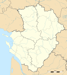 Saintes | ||
| Coordinates: 45°44′47″N 0°38′00″W / 45.7464°N 0.6333°WCoordinates: 45°44′47″N 0°38′00″W / 45.7464°N 0.6333°W | ||
| Country | France | |
| Region | Poitou-Charentes | |
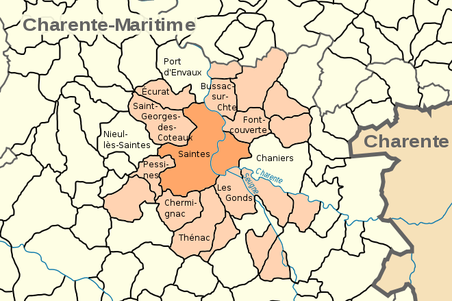
| Department | Charente-Maritime | |
| Arrondissement | Saintes | |
| Area1 | 45.55 km2 (17.59 sq mi) | |
| Population (2008)2 | 26,470 | |
| • Density | 580/km2 (1,500/sq mi) | |
| INSEE/Postal code | 17415 / 17100 | |
| Elevation |
2–81 m (6.6–265.7 ft) (avg. 47 m or 154 ft) | |
|
1 French Land Register data, which excludes lakes, ponds, glaciers > 1 km² (0.386 sq mi or 247 acres) and river estuaries. 2 Population without double counting: residents of multiple communes (e.g., students and military personnel) only counted once. | ||

.svg.png)
Saintes (French: [sɛ̃t]), is a commune located in southwestern France, in Poitou-Charente and Charente-Maritime department of which it is a sub-prefecture. Its inhabitants are called Saintaises and Saintais.[1] Saintes is the second largest city in Charente-Maritime, with 26,470 inhabitants in 2008; and it has the second largest metropolitan area in the department, with 56,598 inhabitants.
In Roman times, Saintes was known as Mediolanum Santonum, and during much of its history, the name of the city was spelled Xaintes and Xainctes.
Primarily built on the left bank of the river Charente, Saintes became the first Roman capital of Aquitaine, and later, the capital of the province of Saintonge under the Ancien Régime. Following the French Revolution, it briefly became the prefecture of the department (then called Charente-Inférieure) during the territorial reorganization of 1790, until La Rochelle took its place in 1810.[2] Even though it was but a subprefecture,[N 1] Saintes was allowed to remain the center of the judiciary life in the department. In the last third of the 19th century, Saintes was chosen as the seat of the VIIIth arrondissement of the Chemins de Fer de l'État, which enabled an era of economic and demographic growth.
Today, Saintes remains the economic heart of the center of the department and it is an important transportation hub.[3] Its industry counts but a few companies (electronics industry, rail repair, construction of hoists), but the city is an important commercial (with the seat of Coop Atlantique) and tertiary center (administrative functions of state, criminal court and judicial activities, banks, schools, hospital).
Because of its noteworthy Gallo-Roman, medieval and classical heritage, Saintes is a popular touristic destination, member of the French Towns and Lands of Art and History since 1990.[4] It has several museums, a theater, cinemas, and organizes numerous festivals.[5] A European center of musical research and practice is located in the Abbaye aux Dames.[6]
Geography
Location
Saintes is located on the banks of the Charente River, in the center-eastern part of the department. The city is located 60 km southeast of La Rochelle,[7] 33 kilometers northeast of Royan[7] and about 100 km north of Bordeaux[7] (to which it is linked by the A10 autoroute).
Geology
A chronostratigraphic stage has been named after Saintes, or more exactly after its ancient inhabitants, the Santones : the Santonian (approximately 84 Ma ago, after the Coniacian and Campanian). Saintes is indeed built on rocks dating from this period, limestone that consist of particular flint nodules of quartz geodes and nodules of iron. Ancient stone quarries located in Capitol Hill or Bellevue, partially filled or converted to permit fungiculture, make remember that they were long used for the construction of various buildings, though they can be cracked by frost.[8]
Nearer to the river, the Cretaceous plateau gives way to more or less recent alluvial grasslands composed of bri, a type of clay.
The uplifting of Alps and Pyrenees began during the Maastrichtian, 65 Ma ago, and continued for a part of the Paleogene.
Districts
The town is divided in several administrative areas : Les Boiffiers, Les Tourneurs, L'Ormeau de Pied, Recouvrance, La Fenêtre, Saint-Rémy, Saint-Vivien, Saint-Eutrope, Saint-Pierre, Saint-Pallais, Saint-Sébastien de Bouard, La Récluse, Le Maine-Saint-Sorlin and Bellevue.[9]
Left bank (Rive gauche)
The neighborhood of Saint-Pierre lies between the hill of the Capitole and the Charente. It possesses a significant number of historic monuments, which explains its integration in a conservation area[10] that lies over more of 65 ha. Built around the cathedral Saint-Pierre, the place du marché and the place du Synode, it is crossed by pedestrian alleys around which can be found numerous medieval, renaissance and classic buildings.[11]
A little westwards lies the neighbourhood of Saint-Eutrope, that has developed over the centuries around a rocky elevation limited by two small valleys at right angles to the river. Dominated by the basilica Saint-Eutrope, it also contains the remains of a Clunian priory and several hillside houses. Little alleys lead to the vallon des Arènes below, where is situated the Roman amphiteatre, in a park named "Parc des Arènes".[11]
The cours Reverseaux and the cours des Apôtres de la liberté separate the neighborhood of Saint-Eutrope from the faubourg Berthonnière, bordered by the hill of Saint-Eutrope at the west and by the hill of the Capitole at the north. Once located out of the city walls, it included some hostelries and inns for pilgrims.[11] The streets of the faubourg converge toward the place Saint-Louis, the place de l'Aubarrée and the place Blair, dominated by a column of Liberty[12] erected during the Revolution. The square Goulebenéze stands between the place Blair and the river.
The neighbourhoods of les Boiffiers and Bellevue are separated from the rest of the city by the avenue de Saintonge ; they consist mainly in low-rent housing (HLM) and suburban housing standing on a plateau limited by the Charente. Bellevue counts 1,560 inhabitants on 17 ha ; it is listed as a zone urbaine sensible (ZUS).[13]
In a triangle formed by the cours du maréchal Leclerc, the cours Genet and the rocade ouest (bypass), the neighbourhood of Recouvrance contains a lycée, the former seminary, the Yvon Chevalier stadium and a shopping mall. The water tower of Recouvrance is decorated by frescoes by contemporary artist Michel Genty.
The northern part of the agglomeration is formed by the Saint-Vivien neighborhood, an old faubourg occupied since the Antiquity and where are situated the thermes de Saint-Saloine, ancient Roman baths.[11]
Right bank (Rive droite)

The neighborhood of Saint-Pallais was probably urbanized in antiquity. Structured around the main access way of the Roman city, it was then linked to the town center by a bridge with a monumental entrance, the Arch of Germanicus. During the Middle Ages, a funeral basilica, dedicated to the bishop Palladius, was established (and later replaced by the église Saint-Pallais, which gives its name to the neighborhood), then a Benedictine abbey of women amongst the largest in the region, the Abbaye aux Dames de Saintes. The presence of this monumental heritage led to the integration of part of the neighborhood in a conservation area. It was during the 19th century that the neighborhood began to develop. The antique bridge was destroyed and replaced in 1879 by the pont Bernard-Palissy, a few meters upstream ; the avenue Gambetta and the place Bassompierre are created ; the train station, the Gare de Saintes, the prison, the Haras national de Saintes, the parc Pierre-Mendès France, the Jardin public Fernand Chapsal and the protected area of the prairie de la Palu[11] were subsequently created.
Adjacent communes
Roads

Saintes is a transportation hub of some importance, connected by two motorways and several secondary roads, national and departmental, that converge towards the rocade (partly a 2x2) that bypasses the city on its western and southern sides.
The A10 autoroute (France), operated locally by Autoroutes du Sud de la France, passes through the commune in its western part, in a north-south axis. It can be accessed by the interchange 35. By the A10, Saintes is 125 km from Bordeaux, 140 km from Poitiers, 470 km from Paris.
The A837 autoroute is a spur road of the A10 that links Saintes to Rochefort, the third city in the department.

Saintes is also located on the way of the Route Centre-Europe Atlantique, an expressway that links it to Limoges and Lyon in the east. The section Saintes-Saujon (2x2 ways) has been opened to traffic in 2008 ; the towns are now 25 minutes apart by car. An extension towards Royan will be made.
The rocade is formed in its western part by the national road 137, that meets two important ways, the departmental road 728 (that links Saintes to the Island of Oleron by Marennes) and the departmental road 150 that intersects with the rocade near the locality of Diconche. In its southern part, the rocade integrates the national road 141, that runs towards Cognac, Angoulême and Limoges. The departmental road 150, at the end of the east part, runs towards Niort by Saint-Hilaire-de-Villefranche et Saint-Jean-d'Angély. The town center of Saintes is bypassed by the avenue de Saintonge or departmental road 24, that crosses the Charente with the bridge de Saintonge, opened in 1969.
Train
The Gare de Saintes (train station) is located at the focal point of five railways that link the agglomeration to Nantes (by La Rochelle), Bordeaux, Angoulême, Niort and Royan ; the trains are mainly part of the regional rail network TER Poitou-Charentes and the network Corail Intercités
In 1894, the station was the starting point of a 3 km long network of tramways that was stopped in 1934. In 1894 was also founded a secondary railway 42 km long linking Saintes to Mortagne-sur-Gironde, by Gémozac, then a somewhat important economic center ; however, this railway was dismantled in 1947.[14]
The importance of this railway network is explained by the designation of Saintes as the seat of the Compagnie des chemins de fer des Charentes in 1867, then as the regional seat of the VIIIth arrondissement of the Chemins de fer de l'État from 1911 to 1971. The SNCF is still a major employer in the city, and new depots and workshops have been opened in 2009 and 2010.
Population
| Historical population | ||
|---|---|---|
| Year | Pop. | ±% |
| 1821 | 10,274 | — |
| 1831 | 10,437 | +1.6% |
| 1836 | 9,559 | −8.4% |
| 1841 | 9,994 | +4.6% |
| 1846 | 11,363 | +13.7% |
| 1851 | 11,569 | +1.8% |
| 1856 | 11,927 | +3.1% |
| 1861 | 10,962 | −8.1% |
| 1866 | 11,570 | +5.5% |
| 1872 | 12,437 | +7.5% |
| 1876 | 13,725 | +10.4% |
| 1881 | 15,763 | +14.8% |
| 1886 | 17,327 | +9.9% |
| 1891 | 18,461 | +6.5% |
| 1896 | 20,285 | +9.9% |
| 1901 | 18,219 | −10.2% |
| 1906 | 19,025 | +4.4% |
| 1911 | 20,802 | +9.3% |
| 1921 | 19,152 | −7.9% |
| 1926 | 20,469 | +6.9% |
| 1931 | 20,592 | +0.6% |
| 1936 | 21,160 | +2.8% |
| 1945 | 23,441 | +10.8% |
| 1954 | 23,768 | +1.4% |
| 1962 | 25,717 | +8.2% |
| 1968 | 26,507 | +3.1% |
| 1975 | 26,891 | +1.4% |
| 1982 | 25,471 | −5.3% |
| 1990 | 25,874 | +1.6% |
| 1999 | 25,595 | −1.1% |
| 2006 | 26,531 | +3.7% |
| 2008 | 26,470 | −0.2% |

Sights

- The Arch of Germanicus, a triumphal arch, was built at the entrance to a bridge, where the main Roman road crossed the Charente River. The bridge was demolished in 1843 but the Arch was saved by Prosper Mérimée and rebuilt at its present location on the bank of the river.
- Ruins of the Roman amphitheatre can be found on the left bank of the Charente, near the summit of the hill upon which the town was built. It is notable in that its tiers (the cavea) are built against the hill and an embankment.
- Some remnants of the thermae of Saint-Saloine (1st century) are also visible, in particular an aqueduct.
- Fragments of the 3rd century rampart can be seen in the Place des Récollets. It was built with stones taken from the Roman buildings.
- The Abbaye-aux-Dames, Madame de Montespan was educated here.
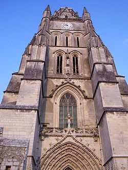
- Saintes is also known for its other churches: the Basilique Saint-Eutrope (Basilica of Saint Eutropius) and the Cathédrale Saint-Pierre. Saintes Cathedral: Basilique Saint-Eutrope: ,
The main museums include:
- the Musée archéologique, which owns a Roman cart of the 1st century amongst a collection of sculptures and inscriptions.
- the Musée du Présidial, which has a mannerist architecture and a collection of regional ceramics and paintings of the 15th to 18th century.
- the Musée de l'Échevinage, which exhibits porcelain of Sèvres and paintings of the 19th and 20th century
Education
Saintes is located in the académie de Poitiers.
|
|
|
- Two American Universities conduct year round study abroad programs at the C.E.A.U., the University of Houston's Gerald D. Hines College of Architecture, and the University of Southern California.
Twin towns
Saintes is twinned with:[15]
-
.svg.png) Nivelles, Belgium
Nivelles, Belgium -
 Xanten, Germany
 -
 Timbuktu, Mali
 -
 Vladimir, Russia
 -
 Salisbury, England
 -
 Cuevas del Almanzora, Spain
See also
- Saintongeais language
- Communes of the Charente-Maritime department
Notes
- ↑ The prefecture of Charente-Maritime is La Rochelle and the subprefectures are, alphabetically: Jonzac, Rochefort, Saint-Jean-d'Angély and Saintes.
References
- ↑ "Gentilé Saintes" (in French).
- ↑ (French) Charente-Maritime, encyclopédie Bonneton, p. 64
- ↑ "Saintes : Pôle économique". Ville de Saintes (in French). Retrieved 27 August 2010.
- ↑ "Le label Ville d'art et d'histoire". L'atelier du patrimoine de Saintonge (in French). Retrieved 9 January 2010.
- ↑ "Saintes : Culture et Patrimoine". Ville de Saintes (in French). Retrieved 27 August 2010.
- ↑ (French) Synthèse des travaux de la commission de stratégie, L'abbaye aux Dames, centre européen de recherche et de pratique musicale de Saintes, note de réflexion stratégique, 2003, Read online
- ↑ 7.0 7.1 7.2 "Calcul de l'orthodromie entre Saintes et La Rochelle". lion1906.com (in French). Retrieved 29 September 2010.
- ↑ Saintes, plus de 2,000 ans d'histoire illustrée, Société d'archéologie et d'histoire de la Charente-Maritime, p.11-14
- ↑ Contrat urbain de cohésion sociale 2007-2012, 80 pages
- ↑ "Le secteur sauvegardé". L'atelier du patrimoine de Saintonge (in French). Retrieved 9 January 2010.
- ↑ 11.0 11.1 11.2 11.3 11.4 "Historique des quartiers". Ville de Saintes (in French). Retrieved 9 January 2010.
- ↑ (French) Le patrimoine des communes de la Charente-Maritime, éditions Flohic, p. 1023
- ↑ "ZUS Bellevue". Website of the ministère du travail, des relations sociales .... et de la ville (in French). Retrieved 29 October 2009.
- ↑ "Les chemins de fer secondaires en France". Fédération des amis des chemins de fer secondaires. Retrieved 9 January 2010.
- ↑ Town hall website: Villes jumelées (French)
Bibliography
- (French) André Baudrit, Saintes au XVIth siècle, (Thèse de Doctorat, Bordeaux 1957), 745 pages.
- (French) Jean Combes, Gilles Bernard, Histoire du Poitou et des Pays Charentais, Éditions de Borée, 2001 ISBN 978-2-84494-084-1
- (French) Robert Favreau, Régis Rech et Yves-Jean Riou (directeurs) Bonnes villes du Poitou et des Pays Charentais (XIIth–XVIIIth siècles), Actes du colloque tenu à Saint-Jean-d’Angély les 24-25 septembre 1999, Société des antiquaires de l'Ouest in Mémoires de la Société des antiquaires de l'Ouest et des Musées de Poitiers, 5th série, tome VIII (2002), à Poitiers. ISBN 2-9519441-0-1
- (French) Michel Garnier, Christian Gensbeit, À la découverte de Saintes, Patrimoines Médias, 2000, ISBN 2-910137-50-3
- (French) Daniel Massiou, Histoire politique, civile et religieuse de la Saintonge et de l'Aunis, A.Charrier, libraire-éditeur, Saintes, 1846.
- (French) Alain Michaud (sous la direction de), Histoire de Saintes, Privat, 1989, ISBN 2-7089-8252-4
- (French) Pierre Rayssiguier (ouvrage collectif sous la direction de), Saintes, plus de 2,000 ans d'histoire illustrée, Société d'archéologie et d'histoire de la Charente-Maritime, Saintes, 2001
- (French) Henri Texier, Petite histoire de Saintes, Geste édition, 2003 ISBN 2-84561-092-0
- (French) Le patrimoine des communes de la Charente-Maritime, éditions Flohic, collection Le patrimoine des communes de France, 2002.
External links
| Wikimedia Commons has media related to Saintes. |
- Saintes History: Urban Development
- (French) Town council site
- (French) Tourism office site
- (French) Pictures of the Abbaye aux Dames
- (French) Pictures of Saint-Eutrope church: and