Sainte-Élizabeth-de-Warwick, Quebec
| Sainte-Élizabeth-de-Warwick | |
|---|---|
| Municipality | |
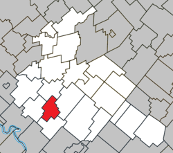 Location within Arthabaska RCM. | |
 Sainte-Élizabeth-de-Warwick Location in southern Quebec. | |
| Coordinates: 45°55′N 72°05′W / 45.917°N 72.083°WCoordinates: 45°55′N 72°05′W / 45.917°N 72.083°W[1] | |
| Country |
|
| Province |
|
| Region | Centre-du-Québec |
| RCM | Arthabaska |
| Constituted | May 18, 1887 |
| Government[2] | |
| • Mayor | Luc Le Blanc |
| • Federal riding | Richmond—Arthabaska |
| • Prov. riding | Drummond–Bois-Francs |
| Area[2][3] | |
| • Total | 51.60 km2 (19.92 sq mi) |
| • Land | 52.08 km2 (20.11 sq mi) |
|
There is an apparent contradiction between two authoritative sources | |
| Population (2011)[3] | |
| • Total | 374 |
| • Density | 7.2/km2 (19/sq mi) |
| • Pop 2006-2011 |
|
| Postal code(s) | J0A 1M0 |
| Area code(s) | 819 |
| Highways | No major routes |
| Website |
www -de-warwick |
Sainte-Élizabeth-de-Warwick is a municipality located in the Centre-du-Québec region of Quebec, Canada.
Before February 2, 2008, the name was spelled Sainte-Élisabeth-de-Warwick.[4]
The municipality is located in the Township of Warwick mainly in the western part of range IV.[5]
References
- ↑ Reference number 400662 of the Commission de toponymie du Québec (French)
- ↑ 2.0 2.1 Geographic code 39090 in the official Répertoire des municipalités (French)
- ↑ 3.0 3.1 "(Code 2439090) Census Profile". 2011 census. Statistics Canada. 2012.
- ↑ http://www.stat.gouv.qc.ca/publications/referenc/pdf2008/Modif_fev08.pdf
- ↑ "French Wikipedia"
 |
Saint-Albert | | ||
| Sainte-Séraphine | |
Warwick | ||
| ||||
| | ||||
| Kingsey Falls |
| ||||||||||||||||||||||