Saint Regis Canoe Area
| St. Regis Canoe Area | |
|---|---|
|
IUCN category Ib (wilderness area) | |
|
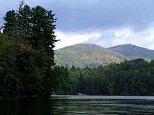
View from Long Pond Mountain of waters of the St. Regis Canoe Area (with the High Peaks in the background) | |
| Location | Adirondack Park, New York, USA |
| Nearest city | Paul Smiths, New York |
| Coordinates | 44°24′40″N 74°19′29″W / 44.41119°N 74.32483°WCoordinates: 44°24′40″N 74°19′29″W / 44.41119°N 74.32483°W |
| Area | 29.5 mi² (76 km²) |
| Governing body | New York State Department of Environmental Conservation |
The Saint Regis Canoe Area is a 19,000 acre (76 km²) area of the Adirondack Park in southern Franklin County, New York about 18 miles (29 km) northeast of Tupper Lake and southwest of Paul Smiths.
It is the largest wilderness canoe area in the Northeast and the only designated canoe area in New York state; it is closed to motor vehicles, motor boats and aircraft. There are 58 ponds and the headwaters of the West and Middle Branch of the Saint Regis and the Saranac Rivers. Only two of the ponds can be reached without a carry. The area is noted for its beauty, wilderness and short canoe carries. Primitive canoe camping is permitted on many of the lakes and ponds. Saint Regis Mountain (2874 ft) and Long Pond Mountain (2530 ft) are within the Canoe Area. The trail to Long Pond Mountain can only be reached by water.
Note: the put ins and take outs and the carry trails can be very muddy at any time of year, and black flies can be extremely active in the spring and early summer.


Ponds
- Bear Pond - two short carries from Upper Saint Regis Lake via tiny Bog Pond, Bear pond is part of the Seven Carries route.
- Bessie Pond - Reached via a 1.5-mile (2.4 km) carry from Long Pond, one of the longer carries in the Canoe Area. One campsite.
- Bone Pond - A very small, rather isolated pond.
- Clamshell Pond - Part of a route from Turtle Pond to Fish Pond; the route has been closed due to beaver activity.
- East Pond - A small pond accessible only by bushwhacking.
- Fish Pond - A medium-sized pond that can be reached by relatively lengthy carries from Long Pond or Saint Regis Pond. Five campsites, two lean-tos.
- Grass Pond - A small pond with two campsites. A beaver stronghold.
- Green Pond - part of the Seven Carries route; oddly, Green Pond is smaller than Little Green Pond.
- Kit Fox Pond - A small pond; part of one route from Long Pond to Fish Pond.
- Ledge Pond - Can be reached by a short carry from Pink Pond.
- Little Green Pond - one of two ponds in the canoe area that do not require a carry to reach; start of the traditional Seven Carries.
- Little Clear Pond - the other pond that does not require a carry to reach; alternate start of the Seven Carries. No fishing or camping.
- Little Long Pond (west of Fish Pond) - Part of one route from Long Pond to Fish Pond.
- Little Long Pond (east of St. Regis Pond) - part of the Seven Carries route.
- Long Pond - at 2 miles (3.2 km) long and 338 acres (1.37 km2), the second largest pond, with two islands. Reached by 0.25 carry from Floodwood Road, 18 campsites.
- Lydia Pond - A small pond, one of the most remote in the Canoe Area; one campsite.
- Monday Pond - A very small pond with one campsite.
- Mountain Pond - A small pond on the trail from Long Pond to Long Pond Mountain.
- Mud Pond - A small pond; part of the route from Saint Regis Pond to Fish Pond, via a carry from Ochre Pond.
- Nellie Pond - Reached via a 1.7-mile (2.7 km) carry from Long Pond, one of the longest carries in the Canoe Area. No campsites.
- Ochre Pond - Part of the route from Saint Regis Pond to Fish Pond.
- Pink Pond - Reachable in high water from Long Pond, no campsites.
- Roiley Pond - A small, isolated pond near the eastern end of the Canoe Area
- Saint Regis Pond - 400 acres (1.6 km2), the largest pond in the canoe area, with four islands. 14 campsites.
- Slang Pond - A small pond, reachable by a 0.15-mile (0.24 km) carry from Long Pond; connects to Turtle Pond. Two campsites.
- Turtle Pond - A small pond that connects Slang Pond to Hoel Pond (just outside of the Canoe Area.
There are also a number of unnamed ponds in the Canoe Area.
See also
Sources
Jamieson, Paul and Morris, Donald, Adirondack Canoe Waters, North Flow, Lake George, NY: Adirondack Mountain Club, 1987. ISBN 0-935272-43-7.

External links
- The Seven and Nine Carries Routes
- St. Regis Canoe Area map, East section
- St. Regis Canoe Area map, West section
- MoshannonFalls - Saint Regis Canoe Area
| ||||||||||||||||||||||||||||||||||||||||||||||||||||||||||||||||||
