Saint John River (Bay of Fundy)
| Saint John River | |
| Rivière Saint-Jean | |
 Saint John River in Fredericton, NB | |
| Countries | United States, Canada |
|---|---|
| State | Maine |
| Provinces | New Brunswick, Québec |
| Tributaries | |
| - left | Tobique River, Jemseg River, Belleisle Bay, Kennebecasis River |
| - right | Allagash River, Aroostook River, Nerepis River |
| Cities | Edmundston, Fredericton, Saint John |
| Primary source | Saint John Ponds |
| - location | Somerset County, Maine, United States |
| - elevation | 360 m (1,181 ft) |
| Secondary source | Little Saint John Lake |
| - location | Saint-Zacharie, Quebec, Canada |
| Additional source | Lac Frontière |
| - location | Montmagny Regional County Municipality, Quebec, Quebec, Canada |
| Source confluence | |
| - location | Aroostook County, Maine, United States |
| - coordinates | 46°33′47″N 69°53′06″W / 46.5630°N 69.8850°W |
| Mouth | Bay of Fundy |
| - location | Saint John, New Brunswick, Canada |
| - coordinates | 45°16′N 66°4′W / 45.267°N 66.067°WCoordinates: 45°16′N 66°4′W / 45.267°N 66.067°W |
| Length | 673 km (418 mi) |
| Basin | 54,986 km2 (21,230 sq mi) |
| Discharge | |
| - average | 990 m3/s (34,962 cu ft/s) |
 The course of the Saint John River
| |
| Designations | |
|---|---|
| Official name | Wolastoq National Historic Site of Canada |
| Designated | 2011 |
The Saint John River (French: Rivière Saint-Jean) is a river, approximately 418 miles (673 km) long, located principally in the Canadian province of New Brunswick but also in, and arising from the province of Quebec and the U.S. state of Maine. It forms part of the Canada – United States border in two different places along its length. The river drains an area of approximately 55,000 square kilometres (21,000 sq mi), of which slightly more than half is located in New Brunswick. Along that portion of the Atlantic shoreline of North America that lies between the St. Lawrence River and the Mississippi River, the Saint John River is the second longest waterway; only the Susquehanna is longer. The lower section of the Saint John River (extending from Fredericton to the City of Saint John) is nicknamed the "Rhine of North America" in reference to its popularity for recreational boating.[1] This section of the river is regulated by a hydro power dam located in Mactaquac, New Brunswick, whose head pond is very popular for boating, water skiing and swimming.
Description
The Baker Branch of the Saint John River rises in the Saint John Ponds of Somerset County in northwestern Maine. The Southwest Branch of the Saint John River originates in Little Saint John Lake on the Maine–Quebec border near Saint-Zacharie, Quebec and forms the international boundary between Maine and Quebec as it flows northeasterly to join the Baker Branch in northern Somerset County. The Northwest Branch of the Saint John River rises from Lac Frontière, in Montmagny Regional County Municipality near the southeastern Quebec border and flows southerly through Maine to a confluence with the Daaquam River and then easterly to a confluence with the Southwest Branch.
The branches combine to form the main river flowing northeastward through western Aroostook County (46°33′47″N 69°53′06″W / 46.5630°N 69.8850°W). The Lacroix road built in 1923 from Lac-Frontière crosses the river at Ninemile Bridge.[2] Near Seven Islands the river was crossed by an 18th century trail from the St. Lawrence River.[3] There is an Abenaki burial site containing a large number of graves where the Big Black River joins the Saint John in township 18, range 13, WELS. Local legend maintains the confluence is haunted by the spirits of Abenaki killed by an epidemic of European disease.[4]
Near Allagash, the Saint John is joined by the Allagash River. The whole portion of the Saint John River that lies entirely in Maine is essentially a wilderness waterway, although many smoothly weathered granite boulders within the channel were broken by blasting during early 20th century log driving.[5] Below St. Francis, the St. John begins to form part of the International Boundary between Maine and New Brunswick.
Continuing its northeasterly course, the river passes Fort Kent, Maine, and then flows between Edmundston, New Brunswick, and Madawaska, Maine, where it turns southeast, passing between Van Buren, Maine, and St. Leonard, New Brunswick. Near Grand Falls, New Brunswick, the river enters entirely into New Brunswick, and changes direction to flow due south through the fertile Upper Saint John River Valley, framed by the rising hills of the Appalachian range in Victoria and Carleton counties. At Perth-Andover, the river is joined by the Aroostook and the Tobique rivers. At Hartland, it is crossed by the longest covered bridge in the world.
Further south at Woodstock, the river leaves the Upper Valley and turns east, heading away from the border region. It is joined by the Nackawic stream at Nackawic and passes small communities such as Bear Island. The Maliseet capital of Meductic was located along the Saint John River in the 17th and into the mid-18th century. This site was flooded in 1968 after completion of the Mactaquac Dam; the river continues eastward until it eventually reaches New Brunswick's capital city Fredericton (where it becomes navigable), and then the military town of Oromocto. Turning south from Oromocto, the river is joined by the short Jemseg River which empties New Brunswick's largest lake, Grand Lake. This part of the river valley becomes broad and shallow. The river is dotted by many low islands used for pastureland during dry periods in the summer and fall.
South of the Jemseg, the Saint John River is surrounded by the low hills of the St. Croix Highlands. It is joined by several lateral bays; including Belleisle Bay, the Nerepis River and the Kennebecasis River. The Saint John River finally discharges into the Bay of Fundy. The industrial city of Saint John is located at the mouth of the river. Near the river's mouth is the site of the Reversing Falls, caused by the high tides of the Bay of Fundy. These tides are the highest in the world and cause the river to reverse its flow twice a day in a narrow gorge in the city's centre.
The Saint John River has a maximum depth of 50 metres.
History
Members of the Wolastoqiyuk Nation, known also as Maliseet, whose lands and culture have been and still are centered on the Saint John River, have historically called the river Wolastoq, translating to "good and beautiful river".
In 1604, parts of the lower river were explored by Samuel de Champlain and Sieur de Monts. Champlain named the river after John the Baptist because he reached the river's mouth on the saint's feast day of June 24. The Maliseet, from their village of Meductic Indian Village / Fort Meductic on the Saint John River, served as allies of the French and conducted numerous raids against the New Englanders below the Kennebecasis River, Maine (i.e., the Acadia/New England border) throughout the French and Indian Wars as well as Father Rale's War.
French colonists developed the lower river valley as an important part of their colony of Acadia. Acadian settlements along the lower river during the 17th and 18th centuries included Fort La Tour (Saint John) and Pointe Sainte-Anne (Fredericton).
In 1758, during the French and Indian War, the North American front of the Seven Years' War, Colonel Robert Monckton began the St. John River Campaign. The British burned the Acadian villages along the river, forcing the inhabitants to flee, or taking them prisoner prior to deportation. The entire area fell under English control after their capture of Fort Sainte-Anne in Fredericton at the end of the St. John River Campaign (1759).
In 1784, many loyalist refugees from the American Revolutionary War were resettled in Saint John, Fredericton, and along the river at other settlements such as Queensbury and Woodstock. The arrival of the Loyalists was the catalyst for organization of the new British colony of New Brunswick. Fredericton was named the capital. British settlement of the fertile Upper River Valley did not take place until the early-to-mid-19th century. An immigrant Danish community (New Denmark) was established in the late 19th century.
In 1785, Acadians returning from the deportation settled in the Upper Saint John River valley, near what is now Edmundston. Somewhat later in the mid-19th century, francophone Quebecers also settled the Madawaska region, travelling southwards along traditional portage routes from the Saint Lawrence River valley. They joined the Acadians. The Madawaska section of the river valley is still strongly francophone in the 21st century.
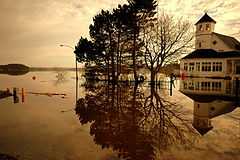
The river was an important trade route for French, English and First Nations traders throughout the 17th and 18th centuries. The tremendous flow rate of the river and its tributaries during the spring freshet aided the development of the timber industry in western New Brunswick, and the river became a conduit for log drives to saw and pulp mills in the south. The spring freshet can prove disastrous to property owners along portions of the river, particularly when ice jams cause extensive flooding during the spring break-up.

With the development of lumbering and agricultural resources, the upper river valley area, by the 1820s and 1830s, became increasingly economically important. Both American and British citizens settled the area and, since the international boundary in this area was poorly defined, conflict between the British colony of New Brunswick and the State of Maine inevitably erupted. The Aroostook War developed when the respective state and colonial militias were called out. The border was ultimately defined by the Webster-Ashburton Treaty of 1848, but land disputes carried on for many years among settlers and lumbermen with legitimate claims.[6]
The Saint John River in the 19th century was integral to the development of western New Brunswick. As it had for thousands of years, it served as the principal transportation artery to the region, particularly prior to the era of rail transport, when paddle wheelers plied its waterways.
New Brunswick industrialist Alexander Gibson commissioned a survey in 1866 for a railway line extending from his mill facilities in South Devon at the river junction with the Nashwaak River opposite Fredericton, north to Edmundston to service timber lands which he leased from the Crown. A charter for the railway was received from the provincial government in 1870 and the New Brunswick Land and Railway Company (NBR) was formed. Part of the charter provided for additional timber land based upon construction performance, thereby making Gibson one of the largest landowners in the province. Andrew George Blair, while Minister of Railways and Canals in the government of Wilfrid Laurier, was instrumental in forging the railway line further onwards to its junction with the rest of Canada in Quebec City. The entire NBR was sold in 1941 by Canadian Pacific Railways, which operated the railway in the first half of the 20th century, to forestry operator J.D. Irving Limited.
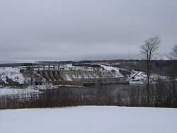
During the 1950s and 1960s, the river was developed as a major source of hydroelectric power with the construction of the Beechwood Dam in 1955 and the Mactaquac Dam in 1968. Large reservoirs were created behind the dams. These massive projects followed the construction of a smaller dam at Grand Falls in 1925, where the river descends in a steep cataract. Construction of the latter two dams has caused a severe decline in migrating Atlantic Salmon, and resource authorities have tried to develop fish ladders and other means to revive the migration. In addition, much fertile farmland was flooded to create the headponds.
In recent years, the river has been a destination for recreational boating and ecotourism. The rich soil of the Upper Saint John River Valley in Carleton and Victoria counties, as well as Aroostook County, Maine, continues to be cultivated for potatoes.
In 2011, the river was designated a National Historic Site of Canada and is noted for its importance to the Wolastoq First Nation.[7]
Water flow
- See also 2008 Saint John River Flood
The United States Geological Survey maintains three gauges on the river to measure water flow on the portion running through its territory. The furthest upstream gauge is located in an unnamed township at (46°42′00″N 69°42′59″W / 46.70000°N 69.71639°W) where the rivershed is 1,341 square miles (3,470 km2). A second gauge is located at Dickey, Maine (47°06′44″N 69°05′25″W / 47.11222°N 69.09028°W) where the rivershed is 2,680 square miles (6,900 km2). The third gauge is maintained in cooperation with the Water Survey of Canada on the Canadian bank in Clair, New Brunswick at (47°15′35″N 68°35′45″W / 47.25972°N 68.59583°W) where the rivershed is 5,665 square miles (14,670 km2).
WSC also maintains its own gauges on the river in New Brunswick at Edmundston, Grand Falls, Fredericton, Maugerville, Upper Gagetown, Gagetown, Oak Point, and Saint John.
At the most upstream gauge the riverflow has ranged from 44,400 cubic feet per second (1,260 m3/s) to 59 cubic feet per second (1.7 m3/s). At the Dickey gauge flow has ranged from 91,700 cubic feet per second (2,600 m3/s) to 129 cubic feet per second (3.7 m3/s). At the Clair gauge flow has ranged from 151,000 cubic feet per second (4,300 m3/s) to 510 cubic feet per second (14 m3/s). Water flow is highest during the spring freshet and lowest in the fall. In early spring, upper sections of the river can experience ice jams causing flooding,[8] while in the lower sections in the broader floodplain, flooding may occur during late spring from the sheer volume of water which must make its way through the narrow gorge at the Reversing Falls.

See also
- List of crossings of the Saint John River
- List of longest rivers of Canada
- List of Maine rivers
- List of New Brunswick rivers
- Port of Saint John
Notes
- ↑ "Geography"
- ↑ Jackson (2007) p. 123
- ↑ Jackson (2007) p. 120
- ↑ Jackson (2007) p. 139
- ↑ Jackson (2007) p. 194
- ↑ Judd (1988)p.32
- ↑ Wolastoq. Directory of Federal Heritage Designations. Parks Canada. Retrieved 4 May 2012.
- ↑ G.J. Stewart, J.P. Nielsen, J.M. Caldwell, A.R. Cloutier (2002). "Water Resources Data - Maine, Water Year 2001" (PDF). Water Resources Data - Maine, Water Year 2001. Archived from the original (PDF) on 2005-11-18. Retrieved 2006-05-07.
References
- Jackson, Annette (2007). My Life in the Maine Woods. Islandport Press. ISBN 0-9763231-9-2.
- Judd, Richard (1988). "Forging an International Economy" in Aroostook, a century of logging in Northern Maine. University of Maine Press.
External links
![]() Media related to Saint John River at Wikimedia Commons
Media related to Saint John River at Wikimedia Commons
- Voici the Valley Audio Story and Guide information and excerpts
- St. John River watershed map and information
- Canadian Council for Geographic Education page with a series of articles on the history of the St. John River
- A book covering the St. John River with full color photos
- Oceanographic study of the salt and fresh water exchange in the lower St. John River
- Real-time river flow at the upstream most gage, Dickey, Maine, or St. Clair, New Brunswick.
- The Upper St. John River Valley history and genealogy.
- National Weather Service forecast of river levels and flow
- Live WebCam coutesy of the Maine Department of Transportation.
- Saint John River, Geographical Names Board of Canada
| ||||||||||||||||||