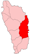
Saint David Parish, Dominica
| Saint David | |
| Parish | |
.jpg) Carib Territory coast | |
| Country | Dominica |
|---|---|
| Capital | Rosalie |
| - coordinates | 15°22′N 61°16′W / 15.367°N 61.267°WCoordinates: 15°22′N 61°16′W / 15.367°N 61.267°W |
| Area | 131.5 km2 (51 sq mi) |
| Population | 6,043 (2011) |
| Density | 46 / km2 (119 / sq mi) |
| Timezone | UTC-4 |
| ISO 3166-2 | DM-03 |
 | |
Saint David is one of Dominica's ten administrative parishes, located on the eastern side of the island. It is bordered by St. Andrew to the north; St. Joseph, St. Paul and St. George to the west; and St. Patrick to the south. It has an area of 131.6 km² (50.8 mi²),[1] and has a population of 6,789.[2]
Settlements
Its largest settlement is Castle Bruce, with a population of 1,653.[2] Other villages include:
- Grand Fond
- Rosalie
- Good Hope
- Petit Soufrière
- Riviere Cyrique
- Morne Jaune
- San Sauveur
Areas of interest
The northern area of the parish is also home to the island's Carib Territory, in and around which 3,000 pure, indigenous Caribs live.