Saint-Symphorien, Cher
| Saint-Symphorien | |
|---|---|
|
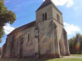
The church in Saint-Symphorien | |
 Saint-Symphorien | |
|
Location within Centre region  Saint-Symphorien | |
| Coordinates: 46°48′46″N 2°18′41″E / 46.8128°N 2.3114°ECoordinates: 46°48′46″N 2°18′41″E / 46.8128°N 2.3114°E | |
| Country | France |
| Region | Centre-Val de Loire |
| Department | Cher |
| Arrondissement | Saint-Amand-Montrond |
| Canton | Châteauneuf-sur-Cher |
| Intercommunality | Rives du Cher |
| Government | |
| • Mayor (2008–2014) | Martine Perrin |
| Area1 | 9.54 km2 (3.68 sq mi) |
| Population (2008)2 | 125 |
| • Density | 13/km2 (34/sq mi) |
| INSEE/Postal code | 18236 / 18190 |
| Elevation |
141–178 m (463–584 ft) (avg. 143 m or 469 ft) |
|
1 French Land Register data, which excludes lakes, ponds, glaciers > 1 km² (0.386 sq mi or 247 acres) and river estuaries. 2 Population without double counting: residents of multiple communes (e.g., students and military personnel) only counted once. | |
Saint-Symphorien is a commune in the Cher department in the Centre region of France.
Geography
A small farming area comprising the village and two hamlets situated by the banks of the tiny river Trian, about 20 miles (32 km) south of Bourges at the junction of the D73 with the D144 road.
Population
| Historical population | ||
|---|---|---|
| Year | Pop. | ±% |
| 1962 | 111 | — |
| 1968 | 129 | +16.2% |
| 1975 | 130 | +0.8% |
| 1982 | 111 | −14.6% |
| 1990 | 114 | +2.7% |
| 1999 | 105 | −7.9% |
| 2008 | 125 | +19.0% |
Sights
- The church of St. Symphorien, dating from the twelfth century (Historic monument).
See also
References
External links
| Wikimedia Commons has media related to Saint-Symphorien (Cher). |
- Official website (French)
- Saint-Symphorien on the Quid website (French)