Saint-Rosaire, Quebec
| Saint-Rosaire | |
|---|---|
| Parish municipality | |
|
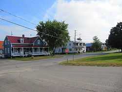
Main street | |
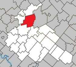 Location within Arthabaska RCM | |
 Saint-Rosaire Location in southern Quebec. | |
| Coordinates: 46°10′N 72°02′W / 46.167°N 72.033°WCoordinates: 46°10′N 72°02′W / 46.167°N 72.033°W[1] | |
| Country |
|
| Province |
|
| Region | Centre-du-Québec |
| RCM | Arthabaska |
| Constituted | May 23, 1896 |
| Government[2] | |
| • Mayor | Harold Poisson |
| • Federal riding | Richmond—Arthabaska |
| • Prov. riding | Arthabaska |
| Area[2][3] | |
| • Total | 109.80 km2 (42.39 sq mi) |
| • Land | 109.40 km2 (42.24 sq mi) |
| Population (2011)[3] | |
| • Total | 838 |
| • Density | 7.7/km2 (20/sq mi) |
| • Pop 2006-2011 |
|
| Postal code(s) | G0Z 1K0 |
| Area code(s) | 819 |
| Highways |
|
| Website |
www strosaire |
Saint-Rosaire is a parish municipality located in the Centre-du-Québec region of Quebec, Canada.
References
External links
-
 Media related to Saint-Rosaire at Wikimedia Commons
 |
Saint-Louis-de-Blandford | | ||
| Sainte-Anne-du-Sault | |
Princeville | ||
| ||||
| | ||||
| Saint-Valère | Victoriaville |
| ||||||||||||||||||||||