Saint-Quentin Parish, New Brunswick
| Saint-Quentin | |
|---|---|
| Parish | |
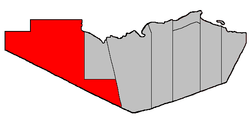 Location within Restigouche County. | |
| Coordinates: 47°45′36″N 67°50′33″W / 47.76°N 67.8425°W | |
| Country |
|
| Province |
|
| County | Restigouche |
| Established | 1920 |
| Area[1] | |
| • Land | 2,478.88 km2 (957.10 sq mi) |
| Population (2011)[1] | |
| • Total | 1,489 |
| • Density | 0.6/km2 (2/sq mi) |
| • Pop 2006-2011 |
|
| • Dwellings | 642 |
| Time zone | AST (UTC-4) |
| • Summer (DST) | ADT (UTC-3) |
Saint-Quentin is a Canadian parish in Restigouche County, New Brunswick.[2]
Delineation
Saint-Quentin Parish is situated at the west end of Restigouche County and is bordered to the east by Eldon Parish and Grimmer Parish. The western boundary is flanked by Madawaska County and to the south lies Victoria County. On the northern border is the province of Quebec.
Communities
Parish population total does not include incorporated municipalities (in bold).
|
|
Demographics
Population
| |||||||||||||||||||
| Historical Census Data - Saint-Quentin Parish, New Brunswick[5] | ||||||||||||||||||||||||||
|---|---|---|---|---|---|---|---|---|---|---|---|---|---|---|---|---|---|---|---|---|---|---|---|---|---|---|
|
|
| ||||||||||||||||||||||||
Language
| Canada Census Mother Tongue - Saint-Quentin Parish, New Brunswick[5] | ||||||||||||||||||
|---|---|---|---|---|---|---|---|---|---|---|---|---|---|---|---|---|---|---|
| Census | Total | French |
English |
French & English |
Other | |||||||||||||
| Year | Responses | Count | Trend | Pop % | Count | Trend | Pop % | Count | Trend | Pop % | Count | Trend | Pop % | |||||
| 2011 |
1,480 |
1,450 | |
97.97% | 20 | |
1.35% | 5 | |
0.34% | 5 | |
0.34% | |||||
| 2006 |
1,585 |
1,435 | |
90.54% | 70 | |
4.42% | 0 | |
0.00% | 80 | |
5.05% | |||||
| 2001 |
1,540 |
1,530 | |
99.35% | 0 | |
0.00% | 10 | |
0.65% | 0 | |
0.00% | |||||
| 1996 |
0 |
1,515 | n/a | 0.00% | 35 | n/a | 0.00% | 0 | n/a | 0.00% | 0 | n/a | 0.00% | |||||
Access Routes
Highways and numbered routes that run through the parish, including external routes that start or finish at the parish limits:[6]
|
|
|
|
See also
References
- ↑ 1.0 1.1 1.2 2011 Statistics Canada Census Profile: Saint-Quentin Parish, New Brunswick
- ↑ New Brunswick Provincial Archives - Saint-Quentin Parish
- ↑ "2006 Community Profiles". Canada 2006 Census. Statistics Canada. March 30, 2011. Retrieved 2014-03-21.
- ↑ "2001 Community Profiles". Canada 2001 Census. Statistics Canada. February 17, 2012. Retrieved 2014-03-21.
- ↑ 5.0 5.1 Statistics Canada: 1996, 2001, 2006, 2011 census
- ↑ Atlantic Canada Back Road Atlas ISBN 978-1-55368-618-7 Pages 12-13
 |
Témiscouata Regional County Municipality |
Rimouski-Neigette Regional County Municipality / La Mitis Regional County Municipality |
Avignon Regional County Municipality |
|
| Saint-Joseph Parish / Rivière-Verte Parish / Sainte-Anne Parish (Madawaska County) |
|
Grimmer Parish / Eldon Parish | ||
| ||||
| | ||||
| Drummond Parish (Victoria County) |
Denmark Parish (Victoria County) |
Lorne Parish (Victoria County) |
| ||||||||||||||||||
Coordinates: 47°45′36″N 67°50′33″W / 47.76000°N 67.84250°W